Edale circular - 14/04/2012
Drove to Edale (yet again!) with my good friend Paul and met up with my sister, Tamara, her husband Robert and the uber-well-behaved dog Dexter. We did 10 miles by heading to Back Tor, Mam Tor, Rushup Edge, Lord's Seat and then over the moors to the ventilation shaft above Cowburn Tunnel. It was very bleak and even started to snow. We then headed NE across more moors until we got to the head of a stream I can't find a name for on any map. Tam and Robert backtracked at this point whilst Paul and I scrambled all the way down the long gulley to a cache at the bottom. We then all met up and walked back to Edale. Total route 10.2 miles. 3 caches.
Dale Dyke - 21/04/2012
Drove to Lower Bradfield and met up with Tam and her supposed gang of Three Peakers - more news on next post. In the end it was only us two and Bill who Tam works with. We walked 9.1 miles around Dale Dyke reservoir and up and over Ughill Moors. No caches but a lovely walk.
PS. Forgot to add - I did this walk with 11 books in my rucksack to build strength!
Showing posts with label edale. Show all posts
Showing posts with label edale. Show all posts
Saturday, 21 April 2012
Wednesday, 28 March 2012
Kinder Scout - yet again!
At last I'm back.
The guilt caught up with me and I decided to ignore the kids' grumbles and go out for a proper walk; my first this year. Adam's had plenty of band practice and several gigs recently, making me feel like a taxi driver, that I put my foot down and planned a full day out. Then I get 8 hours notice for when and where he needs to be - so I put my foot down. Tough luck. The band can suffer and perhaps plan a little more in advance - it's my weekend as well as theirs.
On Thursday, before I knew all the above, I had planned another excursion around Kinder Scout as it is one of my favourite walking places; it's quite near (about an hours drive) and also has many different routes and views. As a bonus there's also some caches.
We set off at 8:30 Sunday morning (clocks forward, 7:30 in my head) and drove there in thick fog. It was quite scary in places and I'm no slouch when it comes to driving but there are people asking for trouble. We arrived safely at 9:30 and I parked at the bottom of Edale, below the railway station, and we set off up the road. It was still misty in places.
Up the road, round the back of the pub and head off up towards Ringing Roger. Blimey it was hard. The raincoat was off after 10 minutes, the long-sleeved shirt after another 10. Huffing and puffing up to the first cache "Anniversary View" (about half way up the hill) it was an easy find, a difficult sign (soggy book) and then back to the kids who'd waited about 50m away. Back to the cache for my walking pole. Back to the kids. I took a short break here while we all slapped some suncream on - the sun was burning through the remains of the mist and you could tell it was going to be a glorious day. Unlike my last visit to Kinder THIS time I was prepared.

Edale in the mist
Now dear Reader, hold your forefinger and thumb about 0.5 centimetres apart. Continuing up the hill I was this close to quitting. I know I've not been out this year and it always takes me a while to get going but this was terrible, I was exhausted. We struggled up to the top, I say we but I mean Jade and I as Adam was fine, and we bore off left at Ringing Roger around towards Upper Tor (this is all on Kinder Plateau.)
Thankfully all the altitude work was now done and as we found another cache I decided at 11:30 to stop for a cup of tea and a rest. Sitting in the glorious sun I realised how beautiful the misty views were over Grindsbrook River and Edale so we made the break into an early lunch and soaked up the distant thinning mist and the microscopic runners on the next brow. (There was some annual running event going on, which had started at 10:30, of which a passing hiker had kindly informed us.)

Half way along the top of Grindsbrook
We took our break at leisure, about 45 minutes, and then continued West along the edge of Kinder towards the top of Grindsbrook, passing the point where I ran out of water on my last visit on a baking hot day. Today was warm but perfect, not too hot.
Continuing along to the top of Crowden Brook I we veered off the trail towards another cache "Noe Head for Heights" which Jade found quickly whilst I was looking lower down the rocky outcrop. Continuing on towards the top of the River Noe I had to inform Adam he was going to be late. He wanted to be in Sheffield for 3:30 and we had an hours drive home, he wanted to shower and change and then be taken back into Sheffield. I told him 5pm but privately thought it would be earlier - give them (the band) the worse case scenario and they can deal with it rather than put them off again and maybe again.
At this point we started to face runners coming towards us, the best of the best as there were only a few. They looked better than I felt. I was ashamed.

Adam posing as always. Jade just looks naturally beautiful.
We got the furthest West point of our circular route (near Kinder Low) and started to head South towards another cache "Cracker of a View" where I left the kids on the trail and climbed up 15 metres to the rocks and fortunately quickly found the cache.
We then headed East along a good trail, now passing many runners (or were they passing us?), but fortunately we got out of their way by turning off the main trail to head down Jacob's Ladder. After the lovely walk along the tops this was where the tiredness in your legs started to kick in and it was hard work going down the rocky path. Even Adam was feeling the pain here.
We passed a cache here that I had to leave, it was about 15m below the path and I knew that by the time I'd descended, found it and reascended it would have been at least 15 minutes and I was very conscious of Adam's sound check. No worries - I'll be back one day, I'm sure of it.
We drifted South-East and then East alongside the River Noe (more of a trickle to be honest) and then over Crowden Brook at Upper Booth, all relatively easy going with a gentle stroll along and slightly down fields. After Upper Booth we had a quick detour off the Trans-Pennine-Trail to pick up our final cache "Korean Bed Lab" (no idea why it's named as it is, I never read it.) At this point my legs were like jelly and my right ankle was really hurting. I'd not twisted it but it felt as though I had and it was hard to bend it upwards so I was struggling on any inclines. Fortunately after about 50 metres we were back on the level and it was all flat and downhill the way home (albeit another 1.4 miles away.)
A quick stop at Edale campsite for a well deserved round of icecreams and then down the road to the car and home.
Adam was at his soundcheck for 4:30.
5 caches but most importantly a fabulous 10 miles (right on the nose) of exhilarating countryside in gorgeous weather.
My lack of fitness opened my eyes to the task I have ahead of me in June (the National Three Peaks) which will be 3 times this difficulty AT LEAST, and all within 24 hours. However I'm confident I can get back to last years levels and succeed. Especially with my sister there to kick me up the behind!
The guilt caught up with me and I decided to ignore the kids' grumbles and go out for a proper walk; my first this year. Adam's had plenty of band practice and several gigs recently, making me feel like a taxi driver, that I put my foot down and planned a full day out. Then I get 8 hours notice for when and where he needs to be - so I put my foot down. Tough luck. The band can suffer and perhaps plan a little more in advance - it's my weekend as well as theirs.
On Thursday, before I knew all the above, I had planned another excursion around Kinder Scout as it is one of my favourite walking places; it's quite near (about an hours drive) and also has many different routes and views. As a bonus there's also some caches.
We set off at 8:30 Sunday morning (clocks forward, 7:30 in my head) and drove there in thick fog. It was quite scary in places and I'm no slouch when it comes to driving but there are people asking for trouble. We arrived safely at 9:30 and I parked at the bottom of Edale, below the railway station, and we set off up the road. It was still misty in places.
Up the road, round the back of the pub and head off up towards Ringing Roger. Blimey it was hard. The raincoat was off after 10 minutes, the long-sleeved shirt after another 10. Huffing and puffing up to the first cache "Anniversary View" (about half way up the hill) it was an easy find, a difficult sign (soggy book) and then back to the kids who'd waited about 50m away. Back to the cache for my walking pole. Back to the kids. I took a short break here while we all slapped some suncream on - the sun was burning through the remains of the mist and you could tell it was going to be a glorious day. Unlike my last visit to Kinder THIS time I was prepared.

Edale in the mist
Now dear Reader, hold your forefinger and thumb about 0.5 centimetres apart. Continuing up the hill I was this close to quitting. I know I've not been out this year and it always takes me a while to get going but this was terrible, I was exhausted. We struggled up to the top, I say we but I mean Jade and I as Adam was fine, and we bore off left at Ringing Roger around towards Upper Tor (this is all on Kinder Plateau.)
Thankfully all the altitude work was now done and as we found another cache I decided at 11:30 to stop for a cup of tea and a rest. Sitting in the glorious sun I realised how beautiful the misty views were over Grindsbrook River and Edale so we made the break into an early lunch and soaked up the distant thinning mist and the microscopic runners on the next brow. (There was some annual running event going on, which had started at 10:30, of which a passing hiker had kindly informed us.)
Half way along the top of Grindsbrook
We took our break at leisure, about 45 minutes, and then continued West along the edge of Kinder towards the top of Grindsbrook, passing the point where I ran out of water on my last visit on a baking hot day. Today was warm but perfect, not too hot.
Continuing along to the top of Crowden Brook I we veered off the trail towards another cache "Noe Head for Heights" which Jade found quickly whilst I was looking lower down the rocky outcrop. Continuing on towards the top of the River Noe I had to inform Adam he was going to be late. He wanted to be in Sheffield for 3:30 and we had an hours drive home, he wanted to shower and change and then be taken back into Sheffield. I told him 5pm but privately thought it would be earlier - give them (the band) the worse case scenario and they can deal with it rather than put them off again and maybe again.
At this point we started to face runners coming towards us, the best of the best as there were only a few. They looked better than I felt. I was ashamed.

Adam posing as always. Jade just looks naturally beautiful.
We got the furthest West point of our circular route (near Kinder Low) and started to head South towards another cache "Cracker of a View" where I left the kids on the trail and climbed up 15 metres to the rocks and fortunately quickly found the cache.
We then headed East along a good trail, now passing many runners (or were they passing us?), but fortunately we got out of their way by turning off the main trail to head down Jacob's Ladder. After the lovely walk along the tops this was where the tiredness in your legs started to kick in and it was hard work going down the rocky path. Even Adam was feeling the pain here.
We passed a cache here that I had to leave, it was about 15m below the path and I knew that by the time I'd descended, found it and reascended it would have been at least 15 minutes and I was very conscious of Adam's sound check. No worries - I'll be back one day, I'm sure of it.
We drifted South-East and then East alongside the River Noe (more of a trickle to be honest) and then over Crowden Brook at Upper Booth, all relatively easy going with a gentle stroll along and slightly down fields. After Upper Booth we had a quick detour off the Trans-Pennine-Trail to pick up our final cache "Korean Bed Lab" (no idea why it's named as it is, I never read it.) At this point my legs were like jelly and my right ankle was really hurting. I'd not twisted it but it felt as though I had and it was hard to bend it upwards so I was struggling on any inclines. Fortunately after about 50 metres we were back on the level and it was all flat and downhill the way home (albeit another 1.4 miles away.)
A quick stop at Edale campsite for a well deserved round of icecreams and then down the road to the car and home.
Adam was at his soundcheck for 4:30.
5 caches but most importantly a fabulous 10 miles (right on the nose) of exhilarating countryside in gorgeous weather.
My lack of fitness opened my eyes to the task I have ahead of me in June (the National Three Peaks) which will be 3 times this difficulty AT LEAST, and all within 24 hours. However I'm confident I can get back to last years levels and succeed. Especially with my sister there to kick me up the behind!
Monday, 25 July 2011
Crookstone and Grinds Brook
24/07/2011
A little disappointed with myself because I'd not managed to do the second walk yesterday owing to lack of water, energy and suncream, I toyed with the idea of going back to do it today.
But then I thought to myself... I've no kids this weekend, why not a) do something they wouldn't want to do and b) why don't I push myself a bit?
Crookstone Knoll came to mind; this was a walk up Kinder Scout I'd planned several months previously which took a relatively easy route (by Kinder standards) to the plateau and then all the way along to pick up some of my neighbour's caches (Yorkypudding and Aginghippy aka Sarah and Kevin) leading back down into Edale.
So, in no rush, I was up at nine packing lunch and preparing again for another full day walking. I arrived at Edale for 11:10am, parked up, readied myself, quickly found an urban cache and then set off along the B-road back towards Hope.
My plan here was to walk the couple of miles along the road whilst my legs eased up from yesterday. The sun was out, it was another glorious day and I set off with a strong pace.
This didn't look good. My legs were really aching and arriving at the second cache "Crookstone Knoll 1", after 1.5 miles along a flat road, I was thinking to myself that the day would be a disaster. Spending five minutes looking for and signing this cache I then set off again and after a minute or so I noticed that my legs were feeling fine; either it was 'just that time' or maybe the five minute break had given my legs chance to clear out some lactic acid.
Two miles into the walk I left the road and started a very gentle climb up the moorland fields to an easy find for Crookstone #2. From here the going got tougher until I dipped back down across a stream and back up the other side. Really simple finds for Crookstone caches #3, #4 and #5 and something struck me; my right arm was starting to hurt.
OH FOR GOODNESS SAKE, THE IDIOT HAS FORGOTTEN HIS SUNCREAM FOR THE SECOND DAY RUNNING!
The sun was beating down on one side of me and being fair-skinned I was worried that this was going to be too much. A plan. Fortunately I'd packed my normal lightweight walking coat in case it rained, and also a baseball cap. I put both of these on and wore the cap backwards, feeling like a 'chav' in an attempt to protect my neck. Foolish man, all this and it's only 12:40.
Continuing up to Crookstone #6 and then #7 I stopped under the first shade I'd seen in an hour for lunch - two trees, and briefly helped three lads with a group photo. Taking my coat off so the sweat can evaporate (euw) and enjoying my corned beef salad and mustard I then had to fend off a couple of sheep that were either after my food or the shade - I couldn't decide which. A healthy tomato and celery sticks, all bonus fluids, I saved half my sandwiches so I wasn't too full for this final push to the top.
A tricky magnetic nano on a gatepost for Crookstone #9 then up and up to #10 before struggling with a really tough Crookstone #11 near the summit. I finally found it some distance from where I'd been looking and it taught me to rely on GPS coordinates more than geocaching instinct sometimes! This was the end of the 'Geo-geriatrics' series and a very good one it was too.
A very short distance to the summit and head off NE to get a cache at the high peak of Crookstone Knoll. A good sized well-hidden bonus cache, found, signed, replaced and then...
It was strange.
I'd gone out on my own, braved the 'real world', walked solo to the top of a bloody big hill and found 12 caches on the way. I genuinely shouted "I've done it" across the valley while triumphantly waving my walking pole, and then a euphoria came over me - a feeling partially, no doubt, due to the endorphins kicking in while I'm stopped, and partially the sense of achievement but also a sense of freedom, a sense of escape, the great outdoors, the views, the wind, the sun, the world.
The strangest thing indeed; I could honestly have sat down and cried and even now writing this blog the feelings return.
Deep breath.
Still feeling very moved I started my long journey along the plateau, heading E/SE for almost two miles until I reached Ringing Roger (no I've no idea why either) - an outcrop of rocks overlooking Edale. Still burning up in the sun (with my coat on) I was surprised as I reached these to be suddenly plunged into a gust of wind, nay a gale, that took my cap away and in an amazing ninja-like movement I actually caught it about two feet above my head.
I spent 15 minutes here carefully climbing down the rocks looking for a well hidden cache which I have since awarded a 'favourite' point on the website. A lovely spot although a little hairy in the wind.
I then headed north looking for a path down the mountain that was on my Ordnance Survey map but which I couldn't locate. I could see one that I knew headed south but that went away from where I wanted to be, somewhat west.
I decided to head further north and then head west along the ridge keeping an eye open for another path I knew headed south down the mountain. I never found that one either, so after talking to a knowledgeable lady I decided that as there was no rush I'd head all the way to the top of Grindsbrook a mile or so further west and then take that path down to Edale. I'd not been there before and it would be an adventure.
An adventure, it turns out, that I'd not planned for considering that I'd already done 8.5 miles when I arrived there and I had also run out of water. My t-shirt was sodden and although my arms were safe inside my coat sleeves my neck and face were suffering from the sun.
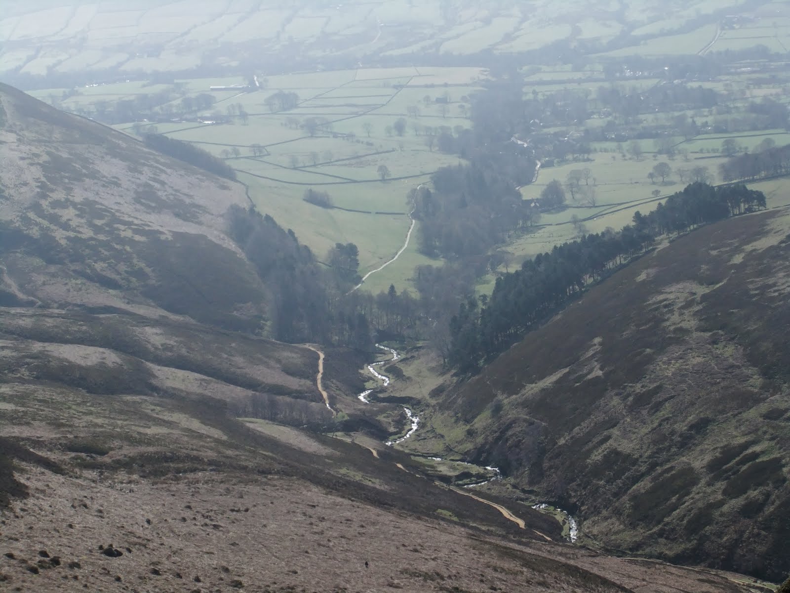
So Grindsbrook stream, the map claims, has a path. Well I can safely inform you that this particular path does not exist, per se, but after spotting others doing the same you realise it is basically a climb down a stream down a mountain; a rocky and potentially dangerous, steep descent. From my tracks I can see that I descended 80 metres in the first 1/6 of a mile and then a further 140 metres over the next 9/10 mile. It was leg breaking, muscle wobbling stuff and I was utterly fatigued.
Some 150 metres below Ringing Roger I finally got to my desired destination and picked up a cache by Sarah and Kevin - Grindsbrook Silver. I cursed them verbally when I saw it was a small climb back up the hillside and decided to stop and have 'second lunch' (it's actually 16:20) while I plucked up the strength and motivation. Another photo service provided for a father and young child sat by the lovely stream here.
Descending further to Grindsbrook Gold and performing maintenance on it for Sarah (taking old logs to give her and replacing with a new one) I knew I was on the last leg of my epic weekend and indeed another agonising 4/5 of a mile later and I was ordering a much needed pint of lemonade at the pub. I sat drinking it slowly for 20 minutes pondering on the day's adventures and my aching legs before heading off on the last half a mile back to the car.
Total for the fantastic day was 11.6 miles, 17 caches and a burnt neck and ears which thankfully do not hurt even though they look pretty bad.
I did take a dozen pictures today but distance and height do not come out very well and they all look the same, even to me, so I'm not going to upload any except for one and one warning...

Top of Grinds Brook

The neck of an idiot
A little disappointed with myself because I'd not managed to do the second walk yesterday owing to lack of water, energy and suncream, I toyed with the idea of going back to do it today.
But then I thought to myself... I've no kids this weekend, why not a) do something they wouldn't want to do and b) why don't I push myself a bit?
Crookstone Knoll came to mind; this was a walk up Kinder Scout I'd planned several months previously which took a relatively easy route (by Kinder standards) to the plateau and then all the way along to pick up some of my neighbour's caches (Yorkypudding and Aginghippy aka Sarah and Kevin) leading back down into Edale.
So, in no rush, I was up at nine packing lunch and preparing again for another full day walking. I arrived at Edale for 11:10am, parked up, readied myself, quickly found an urban cache and then set off along the B-road back towards Hope.
My plan here was to walk the couple of miles along the road whilst my legs eased up from yesterday. The sun was out, it was another glorious day and I set off with a strong pace.
This didn't look good. My legs were really aching and arriving at the second cache "Crookstone Knoll 1", after 1.5 miles along a flat road, I was thinking to myself that the day would be a disaster. Spending five minutes looking for and signing this cache I then set off again and after a minute or so I noticed that my legs were feeling fine; either it was 'just that time' or maybe the five minute break had given my legs chance to clear out some lactic acid.
Two miles into the walk I left the road and started a very gentle climb up the moorland fields to an easy find for Crookstone #2. From here the going got tougher until I dipped back down across a stream and back up the other side. Really simple finds for Crookstone caches #3, #4 and #5 and something struck me; my right arm was starting to hurt.
OH FOR GOODNESS SAKE, THE IDIOT HAS FORGOTTEN HIS SUNCREAM FOR THE SECOND DAY RUNNING!
The sun was beating down on one side of me and being fair-skinned I was worried that this was going to be too much. A plan. Fortunately I'd packed my normal lightweight walking coat in case it rained, and also a baseball cap. I put both of these on and wore the cap backwards, feeling like a 'chav' in an attempt to protect my neck. Foolish man, all this and it's only 12:40.
Continuing up to Crookstone #6 and then #7 I stopped under the first shade I'd seen in an hour for lunch - two trees, and briefly helped three lads with a group photo. Taking my coat off so the sweat can evaporate (euw) and enjoying my corned beef salad and mustard I then had to fend off a couple of sheep that were either after my food or the shade - I couldn't decide which. A healthy tomato and celery sticks, all bonus fluids, I saved half my sandwiches so I wasn't too full for this final push to the top.
A tricky magnetic nano on a gatepost for Crookstone #9 then up and up to #10 before struggling with a really tough Crookstone #11 near the summit. I finally found it some distance from where I'd been looking and it taught me to rely on GPS coordinates more than geocaching instinct sometimes! This was the end of the 'Geo-geriatrics' series and a very good one it was too.
A very short distance to the summit and head off NE to get a cache at the high peak of Crookstone Knoll. A good sized well-hidden bonus cache, found, signed, replaced and then...
It was strange.
I'd gone out on my own, braved the 'real world', walked solo to the top of a bloody big hill and found 12 caches on the way. I genuinely shouted "I've done it" across the valley while triumphantly waving my walking pole, and then a euphoria came over me - a feeling partially, no doubt, due to the endorphins kicking in while I'm stopped, and partially the sense of achievement but also a sense of freedom, a sense of escape, the great outdoors, the views, the wind, the sun, the world.
The strangest thing indeed; I could honestly have sat down and cried and even now writing this blog the feelings return.
Deep breath.
Still feeling very moved I started my long journey along the plateau, heading E/SE for almost two miles until I reached Ringing Roger (no I've no idea why either) - an outcrop of rocks overlooking Edale. Still burning up in the sun (with my coat on) I was surprised as I reached these to be suddenly plunged into a gust of wind, nay a gale, that took my cap away and in an amazing ninja-like movement I actually caught it about two feet above my head.
I spent 15 minutes here carefully climbing down the rocks looking for a well hidden cache which I have since awarded a 'favourite' point on the website. A lovely spot although a little hairy in the wind.
I then headed north looking for a path down the mountain that was on my Ordnance Survey map but which I couldn't locate. I could see one that I knew headed south but that went away from where I wanted to be, somewhat west.
I decided to head further north and then head west along the ridge keeping an eye open for another path I knew headed south down the mountain. I never found that one either, so after talking to a knowledgeable lady I decided that as there was no rush I'd head all the way to the top of Grindsbrook a mile or so further west and then take that path down to Edale. I'd not been there before and it would be an adventure.
An adventure, it turns out, that I'd not planned for considering that I'd already done 8.5 miles when I arrived there and I had also run out of water. My t-shirt was sodden and although my arms were safe inside my coat sleeves my neck and face were suffering from the sun.
So Grindsbrook stream, the map claims, has a path. Well I can safely inform you that this particular path does not exist, per se, but after spotting others doing the same you realise it is basically a climb down a stream down a mountain; a rocky and potentially dangerous, steep descent. From my tracks I can see that I descended 80 metres in the first 1/6 of a mile and then a further 140 metres over the next 9/10 mile. It was leg breaking, muscle wobbling stuff and I was utterly fatigued.
Some 150 metres below Ringing Roger I finally got to my desired destination and picked up a cache by Sarah and Kevin - Grindsbrook Silver. I cursed them verbally when I saw it was a small climb back up the hillside and decided to stop and have 'second lunch' (it's actually 16:20) while I plucked up the strength and motivation. Another photo service provided for a father and young child sat by the lovely stream here.
Descending further to Grindsbrook Gold and performing maintenance on it for Sarah (taking old logs to give her and replacing with a new one) I knew I was on the last leg of my epic weekend and indeed another agonising 4/5 of a mile later and I was ordering a much needed pint of lemonade at the pub. I sat drinking it slowly for 20 minutes pondering on the day's adventures and my aching legs before heading off on the last half a mile back to the car.
Total for the fantastic day was 11.6 miles, 17 caches and a burnt neck and ears which thankfully do not hurt even though they look pretty bad.
I did take a dozen pictures today but distance and height do not come out very well and they all look the same, even to me, so I'm not going to upload any except for one and one warning...

Top of Grinds Brook

The neck of an idiot
Monday, 9 August 2010
Oh the pain!
We signed up for our first Geocaching "event" this weekend and boy did we drop ourselves in at the deep-end! We've not been to an event before so didn't know what to expect but from what I was told on the day this wasn't a typical event; this was simply a walk with a group of friends & Geocachers around a pre-defined route hoping to pick-up a few caches en-route.
The event was published as approximately 13 miles and we knew this was pushing the limits of our fitness - previously we've only done 5, 6 or maybe 7 miles per day. Additionally we were a little dubious about going as we've both been run-down since our holidays and my flight-caught cold had turned into quite a bad cough.
Anyway we decided to take the plunge and set off at 8am on Sunday morning to meet up at Edale. We met a very friendly mixed bunch of people and set off at 9:30.
By 11:00 I thought I was dying. After an easy start, no doubt to throw us off the scent, the route started going up both sides of a tiny stream that trickles down a mountain. I can hardly call it a trail as it was damned near vertical; we rose from 280m above sea-level to 533m within a mile.
This took us to the top of Kinder Scout plateau (made up of, I think, Kinder Scout, Crowden Head and Edale Moor.) We rested and then walked a couple of miles through wet peat (which makes for very tough going with heavy feet and slipping tracks) then we went around the next side of the plateau where the hill is all stones so your ankles are bent every which way and quickly start to ache. Finally about 6 hours later you walk down hill for an hour and your knees and legs feel like collapsing. You don't believe it yourself but the downhill is the worst.
Anyway I know this all sounds like a long grumble but it's not; it is very hard to explain the sheer energy sapping experiences of wading through peat, going downhill knowing you have to then go back up another hill, or carefully picking every single step across a rocky terrain. By 3:15 I would have willingly swapped my house for a helicopter - not the ownership of one, just a two minute ride in one back down to the car. HOWEVER after eight and a half hours we were finally back at the starting point. We'd done some caches (I never took count, they hardly mattered,) we'd done 14.5 miles, we'd gone up to an altitude of 630 metres, we'd fallen over, we'd slipped and got wet & dirty, we'd laughed and we'd made a dozen new friends. It was a great experience.
I'm hoping I'll read this back in years to come and laugh at myself. There were people there of all ages who did it with less effort than we did, a couple of guys even walked around in circles visiting other spots to pass the time while the slow ones caught up. There may be other walkers who read this and think we're total wimps. They're probably right.
However it WAS a personal achievement and, as they say, every great journey starts with a single step. My journey is the journey to fitness. Today I ache, and not as bad as I feared, and I'm also very proud that I have no blisters!
Subscribe to:
Posts (Atom)