Showing posts with label kinder scout. Show all posts

Friday, 1 June 2012

Kinder Butterfly

27/05/2012

My sister asked me to plan something with a couple of good inclines as training towards our National Three Peaks attempt as there are a fair few of the group who've not done much training. Don't ask.

The best hills within a decent driving distance are at one of my favourite walking haunts - Edale and Kinder so I bounced a few ideas back and forth with her before we settled on a plan - we'd do Kinder Scout. Twice.

From past experiences I've found Jagger's Clough and Grindsbrook to be pretty tough ascents so I knocked up a route that started at Edale, headed East and then up Jagger's Clough, West along the top, descend by Ringing Roger, ascend back up Grindsbrook, further West, South and then East down Jacob's Ladder and back to Edale.

From looking at the pre-plotted route you can see why I've called this 'Kinder Butterfly'...

Kinder Butterfly!

We met at 9am (prompt this time!) but disappointingly there were only 3 of the Three Peakers (Jane, David and Helen) as well as my sister (Tam), her husband (Rob), my two kids (Adam and Jade) and my friend (Paul.)

It was a scorching day and I'd well prepared before we set off. The kids and I were already suncreamed up, had loads of food and water and also new boots and hats where necessary.

Approching the start of Jagger's Clough

Ascending Jagger's Clough

Looking down Jagger's Clough
 
Along the tops

We had a great ascent up Jagger's Clough and a quick snack break at the top. The climb wasn't half as tough as I'd remembered but that's probably because I'm 3 years fitter.

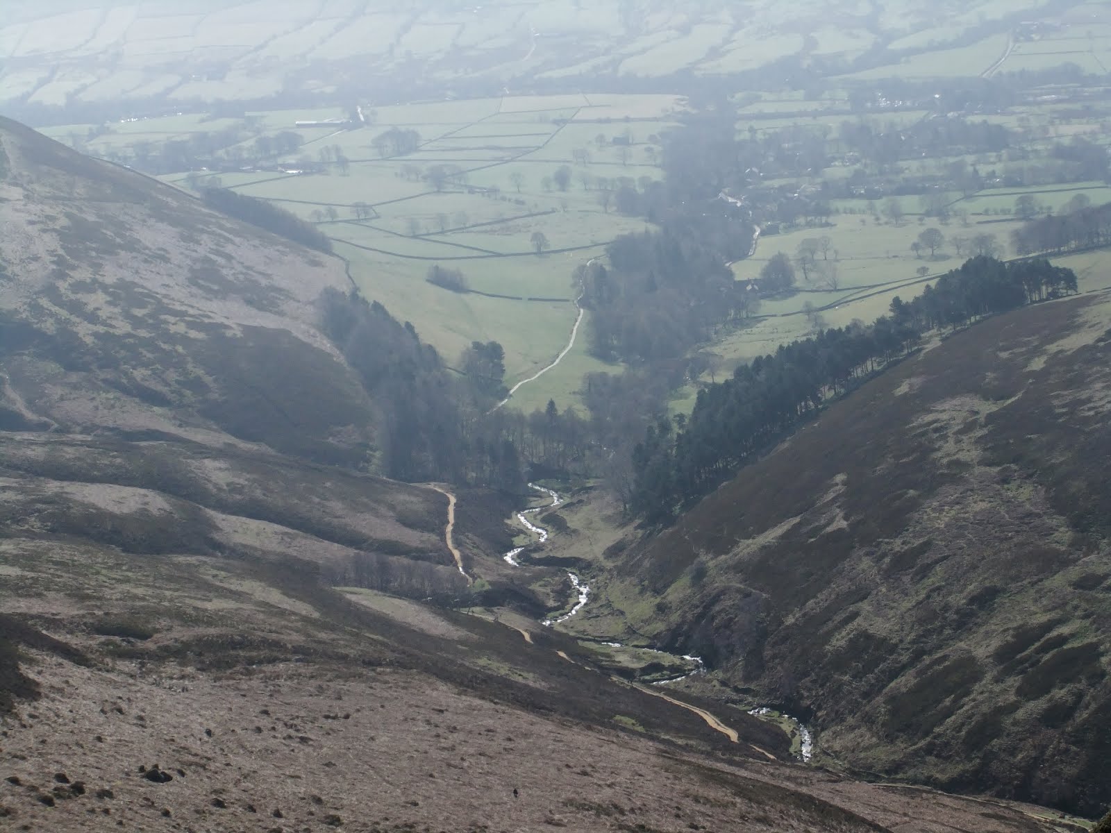
Looking over "Ringing Roger" and down to Edale


From the same location, looking right toward Grindsbrook - our next climb

Someone deserted us at the top, not wanting to descend and re-ascend, which caused us no end of delays two hours later trying to meet up.

After descending we stopped under some trees by a stream to have lunch and a rest before continuing with the long climb up Grindsbrook.


Dexter enjoying our break

Lunchtime!
Adam, Paul, Jade, David, Helen, Jane, Tam and Dexter.

Ascending the lower part of Grindsbrook

I've never done this part upwards, only downwards last year, but it was fabulous. I was still full of energy (we'd only done 7 miles by the top of this part) and really enjoyed bouncing across rocks and the stream. This is where great boots really come into their own. I had to track back a few times as Jade was beginning to struggle in the heat and because she's not actually very fit so I helped pull her up a fair few steep bits to make it much easier. Lots of fun and something I certainly intend to repeat.

At the top we continued in the same direction actually heading directly away from the cars for a couple of miles before turning and descending at Jacob's Ladder where I'd been with the kids only two months earlier. (But this time feeling MUCH fitter.)

Now a long walk back to the car although we did divert from my original route (spoiling my butterfly!) onto the Trans-Pennine-Trail so that we'd end up at the pub and the ice cream shop rather than just back at the car park.

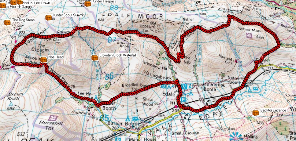
Our actual route.
(Plotted in 3D here so spoiling the 'butterfly' even more.)

In my mind I'd arranged a fabulous route but upon execution I do feel that the last third spoils it a little; once you've done the 'up-down-up' then there are two long walks, split by the last 'down', which have little to offer. Normally these would be lovely walks so perhaps it's just the relative disappointment after the previous exertions?

I have to confess to flagging a little for the last two miles - I'd run out of water after finishing my entire two litres of water but I'd not eaten my Mars Bar. Note to self: it's not much use in the rucksack, it's much more effective in my stomach. However I'm blaming it on the heatwave which, although sapping, wasn't actually as unbearable as I'd feared the day before.

A great walk which I must repeat.

Wednesday, 28 March 2012

Kinder Scout - yet again!

At last I'm back.

The guilt caught up with me and I decided to ignore the kids' grumbles and go out for a proper walk; my first this year. Adam's had plenty of band practice and several gigs recently, making me feel like a taxi driver, that I put my foot down and planned a full day out. Then I get 8 hours notice for when and where he needs to be - so I put my foot down. Tough luck. The band can suffer and perhaps plan a little more in advance - it's my weekend as well as theirs.

On Thursday, before I knew all the above, I had planned another excursion around Kinder Scout as it is one of my favourite walking places; it's quite near (about an hours drive) and also has many different routes and views. As a bonus there's also some caches.

We set off at 8:30 Sunday morning (clocks forward, 7:30 in my head) and drove there in thick fog. It was quite scary in places and I'm no slouch when it comes to driving but there are people asking for trouble. We arrived safely at 9:30 and I parked at the bottom of Edale, below the railway station, and we set off up the road. It was still misty in places.

Up the road, round the back of the pub and head off up towards Ringing Roger. Blimey it was hard. The raincoat was off after 10 minutes, the long-sleeved shirt after another 10. Huffing and puffing up to the first cache "Anniversary View" (about half way up the hill) it was an easy find, a difficult sign (soggy book) and then back to the kids who'd waited about 50m away. Back to the cache for my walking pole. Back to the kids. I took a short break here while we all slapped some suncream on - the sun was burning through the remains of the mist and you could tell it was going to be a glorious day. Unlike my last visit to Kinder THIS time I was prepared.


Edale in the mist

Now dear Reader, hold your forefinger and thumb about 0.5 centimetres apart. Continuing up the hill I was this close to quitting. I know I've not been out this year and it always takes me a while to get going but this was terrible, I was exhausted. We struggled up to the top, I say we but I mean Jade and I as Adam was fine, and we bore off left at Ringing Roger around towards Upper Tor (this is all on Kinder Plateau.)

Thankfully all the altitude work was now done and as we found another cache I decided at 11:30 to stop for a cup of tea and a rest. Sitting in the glorious sun I realised how beautiful the misty views were over Grindsbrook River and Edale so we made the break into an early lunch and soaked up the distant thinning mist and the microscopic runners on the next brow. (There was some annual running event going on, which had started at 10:30, of which a passing hiker had kindly informed us.)


Half way along the top of Grindsbrook

We took our break at leisure, about 45 minutes, and then continued West along the edge of Kinder towards the top of Grindsbrook, passing the point where I ran out of water on my last visit on a baking hot day. Today was warm but perfect, not too hot.

Continuing along to the top of Crowden Brook I we veered off the trail towards another cache "Noe Head for Heights" which Jade found quickly whilst I was looking lower down the rocky outcrop. Continuing on towards the top of the River Noe I had to inform Adam he was going to be late. He wanted to be in Sheffield for 3:30 and we had an hours drive home, he wanted to shower and change and then be taken back into Sheffield. I told him 5pm but privately thought it would be earlier - give them (the band) the worse case scenario and they can deal with it rather than put them off again and maybe again.

At this point we started to face runners coming towards us, the best of the best as there were only a few. They looked better than I felt. I was ashamed.


Adam posing as always. Jade just looks naturally beautiful.

We got the furthest West point of our circular route (near Kinder Low) and started to head South towards another cache "Cracker of a View" where I left the kids on the trail and climbed up 15 metres to the rocks and fortunately quickly found the cache.

We then headed East along a good trail, now passing many runners (or were they passing us?), but fortunately we got out of their way by turning off the main trail to head down Jacob's Ladder. After the lovely walk along the tops this was where the tiredness in your legs started to kick in and it was hard work going down the rocky path. Even Adam was feeling the pain here.

We passed a cache here that I had to leave, it was about 15m below the path and I knew that by the time I'd descended, found it and reascended it would have been at least 15 minutes and I was very conscious of Adam's sound check. No worries - I'll be back one day, I'm sure of it.

We drifted South-East and then East alongside the River Noe (more of a trickle to be honest) and then over Crowden Brook at Upper Booth, all relatively easy going with a gentle stroll along and slightly down fields. After Upper Booth we had a quick detour off the Trans-Pennine-Trail to pick up our final cache "Korean Bed Lab" (no idea why it's named as it is, I never read it.) At this point my legs were like jelly and my right ankle was really hurting. I'd not twisted it but it felt as though I had and it was hard to bend it upwards so I was struggling on any inclines. Fortunately after about 50 metres we were back on the level and it was all flat and downhill the way home (albeit another 1.4 miles away.)

A quick stop at Edale campsite for a well deserved round of icecreams and then down the road to the car and home.

Adam was at his soundcheck for 4:30.

5 caches but most importantly a fabulous 10 miles (right on the nose) of exhilarating countryside in gorgeous weather.

My lack of fitness opened my eyes to the task I have ahead of me in June (the National Three Peaks) which will be 3 times this difficulty AT LEAST, and all within 24 hours. However I'm confident I can get back to last years levels and succeed. Especially with my sister there to kick me up the behind!

Tuesday, 25 October 2011

Fairbrook Naze 1,000

Sunday 23/10/2011

Well aware that I've been creeping towards the thousand-cache marker for a few months I had given a fair bit of thought about where to do it. The "epic gang" that I walk with occasionally, for their 10k and 12k+ caches, had even asked me if I'd got anything in mind back when we did Helvellyn in August.

As it was only 1,000 caches, and with the seasons and weather rolling along, I didn't fancy a long drive up to the Lakes so I looked around for a decent series more local and came up with Fairbrook Naze which starts near the Snake Inn on the A57 and heads up Kinder Scout. I chose this for a few reasons but I think the main one being that I've been caching up there 3 times previously and always enjoyed it. A smaller reason is that the GeoGeriatrics (who I only met once and confess I wouldn't recognise if I met them again) laid down two of the previous series I did up there so I have some respect for their walks and efforts in laying them down.

I now had a dilemma. Well maybe that's too strong a word but my first problem is my kids; they hate Geocaching and they hate walking - they don't appreciate the views, the exercise, the fresh air and the day out. So I've come to an arrangement with them where they have a 'lazy' Saturday and then on Sunday they walk with me. I have to do this as I work five days a week. Anyway this weekend I couldn't leave them with their mother, not that I ever want to do that, but I also didn't want to drag them up a mountain if it was throwing it down. So my problem was this: if I invite people, and they attend, I can hardly abandon the event when I get there and it's raining - I decided not to run the risk. I didn't invite anyone.

I ran my proposed walking route by Patrick, as I know he's done the series very recently, and it turned out that this series and the additional caches I'd planned were exactly as he'd done them - and what's more he'd like to join me to do them again.

So on a dull, yet dry Sunday Patrick picked us up in his van, with Dizzy the dog, and drove us to the A57 where we parked up and set off. I needed 13 to get my 1,000 and hadn't really given much thought to which one it would specifically be as long as it was a Fairbrook Naze one on the way back down.

It was hard work from the off as I'd not warmed up, but also because my rucksack was a whopping 17Kg in weight - yes I'd even weighed it because I had realised it was much heavier than normal, and no wonder...

* 2 litres of water
* 2 small bottles of pop
* 1 flask of tea
* 1 bottle of champagne (!!)
* 4 glasses
* sandwiches for 3
* flapjack, boost bars, crisps
* gloves, hats
* first aid kit

We started with three quick caches, nicely on level terrain, before starting a long gentle climb along the River Ashop towards a couple of points where we needed to gather clues for a mystery cache further up. One of these clue points was at the site of two plane crashes from 1953 where two fighters came down together - presumably after a mid-air collision? There's still debris scattered around and quite rightly a small tribute to the pilots.

All the caches were easy finds because Patrick has done them before and I was quite happy for him to show me where they were and thereby not spoil the flow of the walk. (Yes I'm more of a walker than a Geocacher.)

After about 3.5 miles, 90 minutes from the start, we stopped for a quick cup of tea before starting the hard ascent straight up Kinder with no path - this took us over 20 minutes to get up 130 metres and I was cursing the rucksack I can tell you. (Adam did helpfully keep offering to carry it but I'm determined as I've always seen it as an aid to fitness.)

We stopped and watched the jumbo jets fly overhead - they circle here on the way to Manchester and they looked amazingly close.

Walking along the edge of the plateau for about 1.5 miles, in the freezing wind, we got to the mystery cache and stopped for a lazy lunch sheltered from the wind before getting to our first (actually the last) of the Fairbrook Naze caches - this was number 11 as they're actually numbered ascending up the river for people starting at the bottom.


Adam tucking into his lunch


Patrick and Jade do the same


Laying down to (unsuccessfully) get out of the wind


Dizzy in glorious 3d

Another standalone cache before hitting the actual top of the stream and starting the descent proper. The caches were now numbered simply Fairbrook Naze 10 through 1 and all were simple finds with rather forgettable containers - having said that, these types of walks are more about the walk and the location rather than a fancy box.

My 1,000th cache was actually Fairbrook Naze #5 and we stopped for a couple of pictures and I cracked open the champagne - OK - overpriced sparkling wine. We relaxed over a couple of glasses each before continuing our descent all the way back to the small woods and back up to the car.


My 1,000th cache!
(and a glorious case of hat-hair!)

So that was that. We did about 8.3 miles and bagged 17 caches. Jade was quiet the entire time; in her own world of music. Adam alternated between music, chatting and complaining about the cold. Patrick just boosted ahead and made me suffer from carrying all the excess weight! Only kidding, it was great to have him there for the company, his help and to help me celebrate my 1,000th when I guess he's been there for a good few hundred of the previous ones on the journey here.

Final thanks must go to the GeoGeriatrics for their time and effort in placing the series.

Only 996 to go to the next major milestone!

Monday, 25 July 2011

Crookstone and Grinds Brook

24/07/2011

A little disappointed with myself because I'd not managed to do the second walk yesterday owing to lack of water, energy and suncream, I toyed with the idea of going back to do it today.

But then I thought to myself... I've no kids this weekend, why not a) do something they wouldn't want to do and b) why don't I push myself a bit?

Crookstone Knoll came to mind; this was a walk up Kinder Scout I'd planned several months previously which took a relatively easy route (by Kinder standards) to the plateau and then all the way along to pick up some of my neighbour's caches (Yorkypudding and Aginghippy aka Sarah and Kevin) leading back down into Edale.

So, in no rush, I was up at nine packing lunch and preparing again for another full day walking. I arrived at Edale for 11:10am, parked up, readied myself, quickly found an urban cache and then set off along the B-road back towards Hope.

My plan here was to walk the couple of miles along the road whilst my legs eased up from yesterday. The sun was out, it was another glorious day and I set off with a strong pace.

This didn't look good. My legs were really aching and arriving at the second cache "Crookstone Knoll 1", after 1.5 miles along a flat road, I was thinking to myself that the day would be a disaster. Spending five minutes looking for and signing this cache I then set off again and after a minute or so I noticed that my legs were feeling fine; either it was 'just that time' or maybe the five minute break had given my legs chance to clear out some lactic acid.

Two miles into the walk I left the road and started a very gentle climb up the moorland fields to an easy find for Crookstone #2. From here the going got tougher until I dipped back down across a stream and back up the other side. Really simple finds for Crookstone caches #3, #4 and #5 and something struck me; my right arm was starting to hurt.

OH FOR GOODNESS SAKE, THE IDIOT HAS FORGOTTEN HIS SUNCREAM FOR THE SECOND DAY RUNNING!

The sun was beating down on one side of me and being fair-skinned I was worried that this was going to be too much. A plan. Fortunately I'd packed my normal lightweight walking coat in case it rained, and also a baseball cap. I put both of these on and wore the cap backwards, feeling like a 'chav' in an attempt to protect my neck. Foolish man, all this and it's only 12:40.

Continuing up to Crookstone #6 and then #7 I stopped under the first shade I'd seen in an hour for lunch - two trees, and briefly helped three lads with a group photo. Taking my coat off so the sweat can evaporate (euw) and enjoying my corned beef salad and mustard I then had to fend off a couple of sheep that were either after my food or the shade - I couldn't decide which. A healthy tomato and celery sticks, all bonus fluids, I saved half my sandwiches so I wasn't too full for this final push to the top.

A tricky magnetic nano on a gatepost for Crookstone #9 then up and up to #10 before struggling with a really tough Crookstone #11 near the summit. I finally found it some distance from where I'd been looking and it taught me to rely on GPS coordinates more than geocaching instinct sometimes! This was the end of the 'Geo-geriatrics' series and a very good one it was too.

A very short distance to the summit and head off NE to get a cache at the high peak of Crookstone Knoll. A good sized well-hidden bonus cache, found, signed, replaced and then...

It was strange.

I'd gone out on my own, braved the 'real world', walked solo to the top of a bloody big hill and found 12 caches on the way. I genuinely shouted "I've done it" across the valley while triumphantly waving my walking pole, and then a euphoria came over me - a feeling partially, no doubt, due to the endorphins kicking in while I'm stopped, and partially the sense of achievement but also a sense of freedom, a sense of escape, the great outdoors, the views, the wind, the sun, the world.

The strangest thing indeed; I could honestly have sat down and cried and even now writing this blog the feelings return.

Deep breath.

Still feeling very moved I started my long journey along the plateau, heading E/SE for almost two miles until I reached Ringing Roger (no I've no idea why either) - an outcrop of rocks overlooking Edale. Still burning up in the sun (with my coat on) I was surprised as I reached these to be suddenly plunged into a gust of wind, nay a gale, that took my cap away and in an amazing ninja-like movement I actually caught it about two feet above my head.

I spent 15 minutes here carefully climbing down the rocks looking for a well hidden cache which I have since awarded a 'favourite' point on the website. A lovely spot although a little hairy in the wind.

I then headed north looking for a path down the mountain that was on my Ordnance Survey map but which I couldn't locate. I could see one that I knew headed south but that went away from where I wanted to be, somewhat west.

I decided to head further north and then head west along the ridge keeping an eye open for another path I knew headed south down the mountain. I never found that one either, so after talking to a knowledgeable lady I decided that as there was no rush I'd head all the way to the top of Grindsbrook a mile or so further west and then take that path down to Edale. I'd not been there before and it would be an adventure.

An adventure, it turns out, that I'd not planned for considering that I'd already done 8.5 miles when I arrived there and I had also run out of water. My t-shirt was sodden and although my arms were safe inside my coat sleeves my neck and face were suffering from the sun.

So Grindsbrook stream, the map claims, has a path. Well I can safely inform you that this particular path does not exist, per se, but after spotting others doing the same you realise it is basically a climb down a stream down a mountain; a rocky and potentially dangerous, steep descent. From my tracks I can see that I descended 80 metres in the first 1/6 of a mile and then a further 140 metres over the next 9/10 mile. It was leg breaking, muscle wobbling stuff and I was utterly fatigued.

Some 150 metres below Ringing Roger I finally got to my desired destination and picked up a cache by Sarah and Kevin - Grindsbrook Silver. I cursed them verbally when I saw it was a small climb back up the hillside and decided to stop and have 'second lunch' (it's actually 16:20) while I plucked up the strength and motivation. Another photo service provided for a father and young child sat by the lovely stream here.

Descending further to Grindsbrook Gold and performing maintenance on it for Sarah (taking old logs to give her and replacing with a new one) I knew I was on the last leg of my epic weekend and indeed another agonising 4/5 of a mile later and I was ordering a much needed pint of lemonade at the pub. I sat drinking it slowly for 20 minutes pondering on the day's adventures and my aching legs before heading off on the last half a mile back to the car.

Total for the fantastic day was 11.6 miles, 17 caches and a burnt neck and ears which thankfully do not hurt even though they look pretty bad.

I did take a dozen pictures today but distance and height do not come out very well and they all look the same, even to me, so I'm not going to upload any except for one and one warning...


Top of Grinds Brook


The neck of an idiot