For personal reasons, not to do with walking or Geocaching, I don't think I will be blogging this event. Don't worry, I'm not being moody, mardy or upset about anything but I think it's better that I don't. For now at least.
I will say that unfortunately I didn't complete - my knee went at the bottom of Ben Nevis (after having done it in a reasonable time) and I couldn't do more than 1/3 of Helvellyn (Scafell Pike access roads were all closed because of the endless torrents of rain.) I didn't attempt Snowdon :-(
Half of the group, full respect and salutes to them, DID complete the three. Truly epic.
Monday 25 June 2012
Friday 15 June 2012
Yorkshire Three Peaks
Whilst thinking about training for the National Three Peaks and not really wanting to do the double-ascent of Scafell (because it involved camping in bad weather) I came up with the bright idea of doing the Yorkshire Three Peaks. (See info on Wikipedia.)
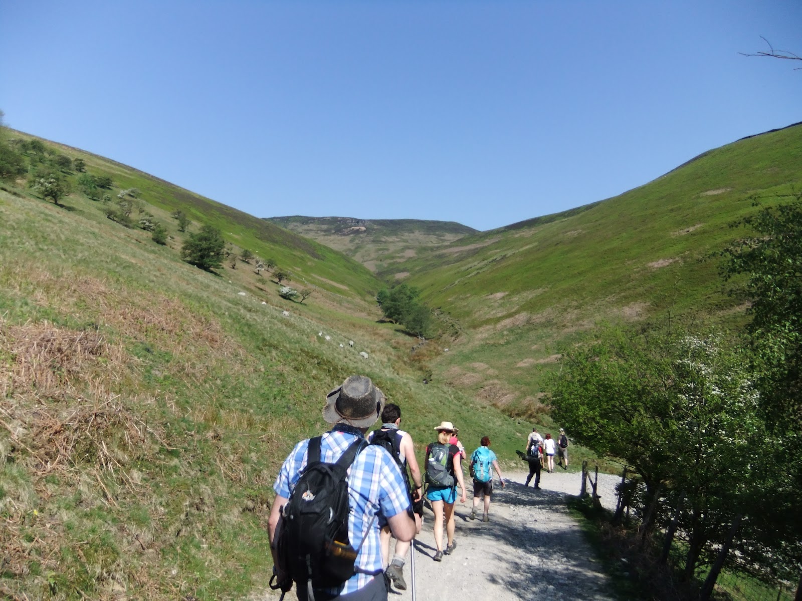
I suggested it to Paul and we set a date for Saturday 9th June with a 7am walking set off - this meant a 5am driving set off. Packed, prepared and up at 4am we arrived at Horton-in-Ribblesdale spot on time. The weather forecast had been dreadful and after a week of non-stop rain we didn't expect much. The drive up had been through glorious sunshine so we had our fingers crossed but once on location it did look overcast.
The start
Opening the car boot I noticed that Paul's rucksack was soaked so I told him to check his water bottles while I went to the loo. He said he thought they were fine. If only I'd been awake.
In the 10 minutes we'd spent putting our boots on the car park had rapidly filled and people were milling around so we set off at pace hoping to leave the crowds behind. Walking along the roads for almost a mile we left civilisation behind and headed off up a track into the misty unknown. We really didn't know what to expect except that it was going to be a tough day and that to 'officially' beat the challenge you have to do it in under 12 hours. Realistically that's pretty easy and I was hoping for 10.5 hours. I think Paul (who has no concept of long distance = more tired = slowing down) was hoping for 8 hours.
Pen-y-ghent
As we couldn't see the top we really had no idea what was in front of us. We climbed up a couple of reasonably steep fields, amongst the crowds, and I kept up a good pace to again beat the queues at stiles and narrow sections.
Being somewhat dehydrated, like I am every morning, I was already sipping on my water tube (Camelbak) and the truth finally sank in - Paul's rucksack was soaked because something had pressed my mouthpiece and had drained out my entire two litres of water into the car boot leaving me with only a backup 300ml bottle. I was worried.
From the road there is a relatively steady 1.3 miles until you hit the steep section and from there you ascend 100m in 1/3 of a mile before the less arduous final 50m in 0.2 of a mile to the summit. The steep section is hard work and at times you're having to pull yourself up; almost climbing rather than walking. This mountain really does start the walk by throwing you in at the deepend. With lead weights.
A quick photo stop at the foggy top, which had taken us a decent 1:02 hours to reach, I checked my water (or lack of) and Paul kindly gave me a bottle he thought he could spare.
The long stretch to the second peak
I didn't want to hang around in the crowds, mainly because I wanted to keep moving while I was still full of energy but also because the weather was miserable, so we cracked straight on with the descent. This was much easier than the ascent as it was gentle and we soon found ourselves heading into the boggy section that I'd heard so much about from Chris at work (who has done this walk twice.)
We found it rather strange that a bog would be on the side of a hill, both assuming that bogs would naturally be in flat areas, and had great fun on the long, wet gamble-of-a-descent whilst both still buzzing from the steep climb. Paul commented about "that" climb and that he'd not expected "that", he didn't know what he was expecting but not "that" and for the rest of his life whenever anyone said "do you remember that?" he would think back to Pen-y-ghent. Laughingly it ultimately transpired that "that" would be replaced within 8 hours!
My gaiters (just had to look up the spelling!) paid for themselves very quickly as my left leg sank into the bog four times over the next hour much to Paul's amusement who unfortunately, for me, avoided any such larks.
With it being nice, cool and damp, I wasn't taking on any water and I started to worry a little less about our supplies but thankfully after 10 miles we passed by a burger van and I bought a couple of bottles to put my mind at rest.
By this time, as we were approaching Ribblehead Viaduct, the sun was out in its glory and it was actually very warm (three seasons in one hour) so we stopped for a short break and I transferred the water to my Camelbak so I could drink more easily 'on the hoof', had a sandwich or two, a banana and Snickers Bar (other chocolates are available!) and Paul changed his socks as his feet were soaked.
Feeling rested we continued...
Whernside
At 11 miles we started a steady circuitous ascent up Whernside. This is a nice gentle walk alongside the railway line before turning North-West and then West steadily gaining in steepness. I had been led to believe this was the easiest peak and I believe in certain circumstance that is probably true but for me today it was the hardest. Over the next 2.6 miles we climbed 400 metres but early on my right ankle started playing up with its unknown tricks. (Mentioned many times in the last few posts and likely a tendon problem.)
To cut a long story short it felt like every 10-20 steps I was being stabbed in the top of my right foot. Excruciating pain like I've never felt and within half an hour I was in utter despair; I knew the walk was over, I'd have to cancel my National Three Peaks walk in two weeks and I'd be lucky to get off this mountain.
Looking back I can see that this sounds like an over-reaction but remembering the sheer pain I was in I can see why I went through all these emotions.
I hobbled on slowly to the top to meet up with Paul who'd been there 10 minutes before me - I hadn't even realised it was the top as I'd lost focus. We stopped for 10 minutes, I had another sandwich and it dawned on me to take some Ibuprofen. I always pack them but as I generally don't take tablets it really was a lucky thought to think to take one. (Which also sounds strange I know.)
The descent starts steadily, which was good, but also with my foot now facing downhill the pain doesn't occur so I worked my way down gingerly and as we got to a much steeper section I overheard two guys chatting about Ben Nevis. Apologising for my overhearing them I asked them which was harder - National or Yorkshire Three Peaks - and pretty much the same as everyone else they couldn't really decide; they're both tough for different reasons.
Onwards to Ingleborough
I chatted merrily away down the steep section and onto a much easier flat section for the next mile and a half and was pleased to be able to ignore my ankle because there was no ascent. We said our goodbyes at a farm where we stopped for Paul to buy a pint of orange juice and had a quick five minutes before continuing.
Passing the pub in Chapel-le-Dale we joked about going in but I knew it would never happen - I'd only need a pint to lose every ounce of energy and would never complete the walk.
Across a couple of fields which were mostly flat we started a long steady climb up the start of Ingleborough. The top was in fog so we'd no idea what was coming but the start seemed pretty reasonable. The level fields turned into long steps and wooden walkways above marshland, getting steeper and steeper until we hit "that".
We thought the first hill was bad but this dwarfed it. Tired from having already completed 18 miles we ascended 150m in 0.5 miles and then another 120m in 0.2 miles - this was TOUGH. Still no idea where we were and now in thick fog I reached a plateau. Ha - a fake peak, so funny.
Following the arrow on my GPS, because I couldn't see anything and Paul had disappeared 10 minutes in front of me, I ventured carefully through the fog - not helped by my reactolite glassed being dark (why?!!?) and the rain on my lenses and a dark shadow slowly loomed out of the mist. I swore. Not to myself either. It seemed like another mountain in front of me but thankfully only turned out to be the last 80m ascent to the top.
The top was bleak. Visiblity was about 15 metres and there were people milling around lost. Maps were useless and no-one seemed to know where to go but thankfully my GPS lead the way and a small group followed me. Fortunately we bumped into Paul who had realised he was in a silent and empty world and had decided to stand still and hope someone turned up.
We made our way the last 50m to the trig point, shook hands and cursed the mountain just as the heavens opened again. I was only wearing a t-shirt, as opposed to Paul and his 4 layers, but I was now starting to feel the cold so I put on some gloves. We had a five minute break and set off back down before I remembered my ankle - it hadn't even twinged during the entire ascent so the Ibuprofen must have worked wonders! (And incidentally it hasn't hurt since, very bizarre.)
Slowly heading down the mountain with a group of lost walkers (go GPS!) I finally had to stop to put on my coat - the rain was too much, and Paul's knee was agony so we dug out some tablets for him too.
The next 4.4 miles were somewhat anti-climactic. The descent would be easy enough, with regards to the incline, but Paul's knee, the endless "moon rocks", the rain, the water and the mud made it incredibly tedious and it took much longer than we'd both have liked.
But we did it.
We completed the Yorkshire Three Peaks in 9:45, much better than I'd hoped, but also with room for future improvement. We congratulated ourselves, changed shoes, ate up the remaining food, rested a while and then set off for the two-hour drive home promising to return one day.
Soon.
I suggested it to Paul and we set a date for Saturday 9th June with a 7am walking set off - this meant a 5am driving set off. Packed, prepared and up at 4am we arrived at Horton-in-Ribblesdale spot on time. The weather forecast had been dreadful and after a week of non-stop rain we didn't expect much. The drive up had been through glorious sunshine so we had our fingers crossed but once on location it did look overcast.
The start
Opening the car boot I noticed that Paul's rucksack was soaked so I told him to check his water bottles while I went to the loo. He said he thought they were fine. If only I'd been awake.
In the 10 minutes we'd spent putting our boots on the car park had rapidly filled and people were milling around so we set off at pace hoping to leave the crowds behind. Walking along the roads for almost a mile we left civilisation behind and headed off up a track into the misty unknown. We really didn't know what to expect except that it was going to be a tough day and that to 'officially' beat the challenge you have to do it in under 12 hours. Realistically that's pretty easy and I was hoping for 10.5 hours. I think Paul (who has no concept of long distance = more tired = slowing down) was hoping for 8 hours.
Pen-y-ghent
As we couldn't see the top we really had no idea what was in front of us. We climbed up a couple of reasonably steep fields, amongst the crowds, and I kept up a good pace to again beat the queues at stiles and narrow sections.
Being somewhat dehydrated, like I am every morning, I was already sipping on my water tube (Camelbak) and the truth finally sank in - Paul's rucksack was soaked because something had pressed my mouthpiece and had drained out my entire two litres of water into the car boot leaving me with only a backup 300ml bottle. I was worried.
From the road there is a relatively steady 1.3 miles until you hit the steep section and from there you ascend 100m in 1/3 of a mile before the less arduous final 50m in 0.2 of a mile to the summit. The steep section is hard work and at times you're having to pull yourself up; almost climbing rather than walking. This mountain really does start the walk by throwing you in at the deepend. With lead weights.
A quick photo stop at the foggy top, which had taken us a decent 1:02 hours to reach, I checked my water (or lack of) and Paul kindly gave me a bottle he thought he could spare.
 |
| Paul and I at the trig point on Pen-y-ghent |
The long stretch to the second peak
I didn't want to hang around in the crowds, mainly because I wanted to keep moving while I was still full of energy but also because the weather was miserable, so we cracked straight on with the descent. This was much easier than the ascent as it was gentle and we soon found ourselves heading into the boggy section that I'd heard so much about from Chris at work (who has done this walk twice.)
 |
| Descending Pen-y-ghent, before we got to the swamp. There are some walkers about 15m in the distance (you can just make them out) who were next to Paul as I readied the camera and who disappeared so quickly into the fog. |
We found it rather strange that a bog would be on the side of a hill, both assuming that bogs would naturally be in flat areas, and had great fun on the long, wet gamble-of-a-descent whilst both still buzzing from the steep climb. Paul commented about "that" climb and that he'd not expected "that", he didn't know what he was expecting but not "that" and for the rest of his life whenever anyone said "do you remember that?" he would think back to Pen-y-ghent. Laughingly it ultimately transpired that "that" would be replaced within 8 hours!
My gaiters (just had to look up the spelling!) paid for themselves very quickly as my left leg sank into the bog four times over the next hour much to Paul's amusement who unfortunately, for me, avoided any such larks.
With it being nice, cool and damp, I wasn't taking on any water and I started to worry a little less about our supplies but thankfully after 10 miles we passed by a burger van and I bought a couple of bottles to put my mind at rest.
 |
| Ribblehead Viaduct |
 |
| And again |
 |
| And again (Paul in Hi-Vis coat!) |
By this time, as we were approaching Ribblehead Viaduct, the sun was out in its glory and it was actually very warm (three seasons in one hour) so we stopped for a short break and I transferred the water to my Camelbak so I could drink more easily 'on the hoof', had a sandwich or two, a banana and Snickers Bar (other chocolates are available!) and Paul changed his socks as his feet were soaked.
Feeling rested we continued...
Whernside
At 11 miles we started a steady circuitous ascent up Whernside. This is a nice gentle walk alongside the railway line before turning North-West and then West steadily gaining in steepness. I had been led to believe this was the easiest peak and I believe in certain circumstance that is probably true but for me today it was the hardest. Over the next 2.6 miles we climbed 400 metres but early on my right ankle started playing up with its unknown tricks. (Mentioned many times in the last few posts and likely a tendon problem.)
To cut a long story short it felt like every 10-20 steps I was being stabbed in the top of my right foot. Excruciating pain like I've never felt and within half an hour I was in utter despair; I knew the walk was over, I'd have to cancel my National Three Peaks walk in two weeks and I'd be lucky to get off this mountain.
Looking back I can see that this sounds like an over-reaction but remembering the sheer pain I was in I can see why I went through all these emotions.
I hobbled on slowly to the top to meet up with Paul who'd been there 10 minutes before me - I hadn't even realised it was the top as I'd lost focus. We stopped for 10 minutes, I had another sandwich and it dawned on me to take some Ibuprofen. I always pack them but as I generally don't take tablets it really was a lucky thought to think to take one. (Which also sounds strange I know.)
The descent starts steadily, which was good, but also with my foot now facing downhill the pain doesn't occur so I worked my way down gingerly and as we got to a much steeper section I overheard two guys chatting about Ben Nevis. Apologising for my overhearing them I asked them which was harder - National or Yorkshire Three Peaks - and pretty much the same as everyone else they couldn't really decide; they're both tough for different reasons.
Onwards to Ingleborough
I chatted merrily away down the steep section and onto a much easier flat section for the next mile and a half and was pleased to be able to ignore my ankle because there was no ascent. We said our goodbyes at a farm where we stopped for Paul to buy a pint of orange juice and had a quick five minutes before continuing.
Passing the pub in Chapel-le-Dale we joked about going in but I knew it would never happen - I'd only need a pint to lose every ounce of energy and would never complete the walk.
Across a couple of fields which were mostly flat we started a long steady climb up the start of Ingleborough. The top was in fog so we'd no idea what was coming but the start seemed pretty reasonable. The level fields turned into long steps and wooden walkways above marshland, getting steeper and steeper until we hit "that".
We thought the first hill was bad but this dwarfed it. Tired from having already completed 18 miles we ascended 150m in 0.5 miles and then another 120m in 0.2 miles - this was TOUGH. Still no idea where we were and now in thick fog I reached a plateau. Ha - a fake peak, so funny.
Following the arrow on my GPS, because I couldn't see anything and Paul had disappeared 10 minutes in front of me, I ventured carefully through the fog - not helped by my reactolite glassed being dark (why?!!?) and the rain on my lenses and a dark shadow slowly loomed out of the mist. I swore. Not to myself either. It seemed like another mountain in front of me but thankfully only turned out to be the last 80m ascent to the top.
The top was bleak. Visiblity was about 15 metres and there were people milling around lost. Maps were useless and no-one seemed to know where to go but thankfully my GPS lead the way and a small group followed me. Fortunately we bumped into Paul who had realised he was in a silent and empty world and had decided to stand still and hope someone turned up.
We made our way the last 50m to the trig point, shook hands and cursed the mountain just as the heavens opened again. I was only wearing a t-shirt, as opposed to Paul and his 4 layers, but I was now starting to feel the cold so I put on some gloves. We had a five minute break and set off back down before I remembered my ankle - it hadn't even twinged during the entire ascent so the Ibuprofen must have worked wonders! (And incidentally it hasn't hurt since, very bizarre.)
 |
| Ingleborough summit. Visiblity about 10 metres. (The fog and rain weren't conducive to a prolonged photo shoot!) |
Slowly heading down the mountain with a group of lost walkers (go GPS!) I finally had to stop to put on my coat - the rain was too much, and Paul's knee was agony so we dug out some tablets for him too.
The next 4.4 miles were somewhat anti-climactic. The descent would be easy enough, with regards to the incline, but Paul's knee, the endless "moon rocks", the rain, the water and the mud made it incredibly tedious and it took much longer than we'd both have liked.
But we did it.
We completed the Yorkshire Three Peaks in 9:45, much better than I'd hoped, but also with room for future improvement. We congratulated ourselves, changed shoes, ate up the remaining food, rested a while and then set off for the two-hour drive home promising to return one day.
Soon.
Friday 1 June 2012
Kinder Butterfly
27/05/2012
My sister asked me to plan something with a couple of good inclines as training towards our National Three Peaks attempt as there are a fair few of the group who've not done much training. Don't ask.
The best hills within a decent driving distance are at one of my favourite walking haunts - Edale and Kinder so I bounced a few ideas back and forth with her before we settled on a plan - we'd do Kinder Scout. Twice.
From past experiences I've found Jagger's Clough and Grindsbrook to be pretty tough ascents so I knocked up a route that started at Edale, headed East and then up Jagger's Clough, West along the top, descend by Ringing Roger, ascend back up Grindsbrook, further West, South and then East down Jacob's Ladder and back to Edale.
From looking at the pre-plotted route you can see why I've called this 'Kinder Butterfly'...
 |
| Kinder Butterfly! |
We met at 9am (prompt this time!) but disappointingly there were only 3 of the Three Peakers (Jane, David and Helen) as well as my sister (Tam), her husband (Rob), my two kids (Adam and Jade) and my friend (Paul.)
It was a scorching day and I'd well prepared before we set off. The kids and I were already suncreamed up, had loads of food and water and also new boots and hats where necessary.
 |
| Approching the start of Jagger's Clough |
 |
| Ascending Jagger's Clough |
 |
| Looking down Jagger's Clough |
 |
| Along the tops |
We had a great ascent up Jagger's Clough and a quick snack break at the top. The climb wasn't half as tough as I'd remembered but that's probably because I'm 3 years fitter.
 |
| Looking over "Ringing Roger" and down to Edale |
 |
| From the same location, looking right toward Grindsbrook - our next climb |
Someone deserted us at the top, not wanting to descend and re-ascend, which caused us no end of delays two hours later trying to meet up.
After descending we stopped under some trees by a stream to have lunch and a rest before continuing with the long climb up Grindsbrook.
 |
| Dexter enjoying our break |
 |
| Lunchtime! Adam, Paul, Jade, David, Helen, Jane, Tam and Dexter. |
 |
| Ascending the lower part of Grindsbrook |
I've never done this part upwards, only downwards last year, but it was fabulous. I was still full of energy (we'd only done 7 miles by the top of this part) and really enjoyed bouncing across rocks and the stream. This is where great boots really come into their own. I had to track back a few times as Jade was beginning to struggle in the heat and because she's not actually very fit so I helped pull her up a fair few steep bits to make it much easier. Lots of fun and something I certainly intend to repeat.
At the top we continued in the same direction actually heading directly away from the cars for a couple of miles before turning and descending at Jacob's Ladder where I'd been with the kids only two months earlier. (But this time feeling MUCH fitter.)
Now a long walk back to the car although we did divert from my original route (spoiling my butterfly!) onto the Trans-Pennine-Trail so that we'd end up at the pub and the ice cream shop rather than just back at the car park.
 |
| Our actual route. (Plotted in 3D here so spoiling the 'butterfly' even more.) |
In my mind I'd arranged a fabulous route but upon execution I do feel that the last third spoils it a little; once you've done the 'up-down-up' then there are two long walks, split by the last 'down', which have little to offer. Normally these would be lovely walks so perhaps it's just the relative disappointment after the previous exertions?
I have to confess to flagging a little for the last two miles - I'd run out of water after finishing my entire two litres of water but I'd not eaten my Mars Bar. Note to self: it's not much use in the rucksack, it's much more effective in my stomach. However I'm blaming it on the heatwave which, although sapping, wasn't actually as unbearable as I'd feared the day before.
A great walk which I must repeat.
Subscribe to:
Posts (Atom)