Monday, 3 September 2012
Summer Catch-up
With a major change of lifestyle occurring over the last couple of months - a new girlfriend (Jane), one-and-a-half extra children, new pets and new responsibilities - I've unfortunately had little chance to do any serious walking despite my new 'better half' loving it.
Here's a catch-up on what I, or we've been up to:
Tenerife
I had two weeks at the end of July in Tenerife where I basically sunbathed and ate continuously. Aside from four very early morning jogs I did very little else - even at 5am I'd have sweat running into my eyes it was so warm. However whilst there I picked up one solitary Geocache just to get one in that country; I actually walked by quite a few others but with the kids, the heat and the muggles I simply didn't have the interest to try harder.
Hope - 13/08/2012
Jane had a few days off so I also took the Monday and drove to Hope where I showed her the "Plummer Circular" - the walk I did back on 12/04/2012 with Chris from work. This is a ten mile walk up Win Hill, across to Hope Cross, down and up to Back Tor and Lose Hill. Jane even talked me into finding the cache on Back Tor that had been bugging me for ages because it was a fair way off the track - and this from someone who has absolutely zero interest in caching!
Messing about along the top from Win Hill to Hope Cross I was jokingly skipping with happiness (who says you have to grow up?) and I twisted my ankle (OK, my body's aged even if my brain hasn't) which spoiled the second half of the walk a bit, but aside from that we had a fabulous day out; perfect weather and perfect company.
Coxley Valley - 18/08/2012
Off to Overton for MikeG's Yorkshire International Geocaching event. It was good to meet everyone I'd not seen for ages and while we were there we did half of his new series; we bailed out after only doing a total of 3 miles as we had to get back in time for our allocated food time-slot.
A lovely afternoon, great food, fabulous weather and bountiful good company.
Wharncliffe Crags - 27/08/2012
Bank Holiday so we left all the kids we had at home to fuel their technology addictions and just took the dog on a long walk around both parts of Wharncliffe Woods & Crags. A great 9.3 mile walk with lots of chat and time to enjoy the views. Life doesn't get much better.
Froggatt Edge - 02/09/2012
Taking Jane to another place she's never visited we parked on the A625 and walked 6.1 miles anti-clockwise around Froggatt Edge. I knew I'd been here before but I didn't remember a second of it - likely because my last visit here was the first outing with Patrick and Donna and we probably talked the whole way round. We're doing ever so well with the weather lately and that, coupled with the great views and fresh air, make for yet another truly amazing day out with the most perfect companion I could hope for.
Monday, 25 June 2012
National Three Peaks
For personal reasons, not to do with walking or Geocaching, I don't think I will be blogging this event. Don't worry, I'm not being moody, mardy or upset about anything but I think it's better that I don't. For now at least.
I will say that unfortunately I didn't complete - my knee went at the bottom of Ben Nevis (after having done it in a reasonable time) and I couldn't do more than 1/3 of Helvellyn (Scafell Pike access roads were all closed because of the endless torrents of rain.) I didn't attempt Snowdon :-(
Half of the group, full respect and salutes to them, DID complete the three. Truly epic.
Friday, 15 June 2012
Yorkshire Three Peaks
Whilst thinking about training for the National Three Peaks and not really wanting to do the double-ascent of Scafell (because it involved camping in bad weather) I came up with the bright idea of doing the Yorkshire Three Peaks. (See info on Wikipedia.)
I suggested it to Paul and we set a date for Saturday 9th June with a 7am walking set off - this meant a 5am driving set off. Packed, prepared and up at 4am we arrived at Horton-in-Ribblesdale spot on time. The weather forecast had been dreadful and after a week of non-stop rain we didn't expect much. The drive up had been through glorious sunshine so we had our fingers crossed but once on location it did look overcast.
The start
Opening the car boot I noticed that Paul's rucksack was soaked so I told him to check his water bottles while I went to the loo. He said he thought they were fine. If only I'd been awake.
In the 10 minutes we'd spent putting our boots on the car park had rapidly filled and people were milling around so we set off at pace hoping to leave the crowds behind. Walking along the roads for almost a mile we left civilisation behind and headed off up a track into the misty unknown. We really didn't know what to expect except that it was going to be a tough day and that to 'officially' beat the challenge you have to do it in under 12 hours. Realistically that's pretty easy and I was hoping for 10.5 hours. I think Paul (who has no concept of long distance = more tired = slowing down) was hoping for 8 hours.
Pen-y-ghent
As we couldn't see the top we really had no idea what was in front of us. We climbed up a couple of reasonably steep fields, amongst the crowds, and I kept up a good pace to again beat the queues at stiles and narrow sections.
Being somewhat dehydrated, like I am every morning, I was already sipping on my water tube (Camelbak) and the truth finally sank in - Paul's rucksack was soaked because something had pressed my mouthpiece and had drained out my entire two litres of water into the car boot leaving me with only a backup 300ml bottle. I was worried.
From the road there is a relatively steady 1.3 miles until you hit the steep section and from there you ascend 100m in 1/3 of a mile before the less arduous final 50m in 0.2 of a mile to the summit. The steep section is hard work and at times you're having to pull yourself up; almost climbing rather than walking. This mountain really does start the walk by throwing you in at the deepend. With lead weights.
A quick photo stop at the foggy top, which had taken us a decent 1:02 hours to reach, I checked my water (or lack of) and Paul kindly gave me a bottle he thought he could spare.
The long stretch to the second peak
I didn't want to hang around in the crowds, mainly because I wanted to keep moving while I was still full of energy but also because the weather was miserable, so we cracked straight on with the descent. This was much easier than the ascent as it was gentle and we soon found ourselves heading into the boggy section that I'd heard so much about from Chris at work (who has done this walk twice.)
We found it rather strange that a bog would be on the side of a hill, both assuming that bogs would naturally be in flat areas, and had great fun on the long, wet gamble-of-a-descent whilst both still buzzing from the steep climb. Paul commented about "that" climb and that he'd not expected "that", he didn't know what he was expecting but not "that" and for the rest of his life whenever anyone said "do you remember that?" he would think back to Pen-y-ghent. Laughingly it ultimately transpired that "that" would be replaced within 8 hours!
My gaiters (just had to look up the spelling!) paid for themselves very quickly as my left leg sank into the bog four times over the next hour much to Paul's amusement who unfortunately, for me, avoided any such larks.
With it being nice, cool and damp, I wasn't taking on any water and I started to worry a little less about our supplies but thankfully after 10 miles we passed by a burger van and I bought a couple of bottles to put my mind at rest.
By this time, as we were approaching Ribblehead Viaduct, the sun was out in its glory and it was actually very warm (three seasons in one hour) so we stopped for a short break and I transferred the water to my Camelbak so I could drink more easily 'on the hoof', had a sandwich or two, a banana and Snickers Bar (other chocolates are available!) and Paul changed his socks as his feet were soaked.
Feeling rested we continued...
Whernside
At 11 miles we started a steady circuitous ascent up Whernside. This is a nice gentle walk alongside the railway line before turning North-West and then West steadily gaining in steepness. I had been led to believe this was the easiest peak and I believe in certain circumstance that is probably true but for me today it was the hardest. Over the next 2.6 miles we climbed 400 metres but early on my right ankle started playing up with its unknown tricks. (Mentioned many times in the last few posts and likely a tendon problem.)
To cut a long story short it felt like every 10-20 steps I was being stabbed in the top of my right foot. Excruciating pain like I've never felt and within half an hour I was in utter despair; I knew the walk was over, I'd have to cancel my National Three Peaks walk in two weeks and I'd be lucky to get off this mountain.
Looking back I can see that this sounds like an over-reaction but remembering the sheer pain I was in I can see why I went through all these emotions.
I hobbled on slowly to the top to meet up with Paul who'd been there 10 minutes before me - I hadn't even realised it was the top as I'd lost focus. We stopped for 10 minutes, I had another sandwich and it dawned on me to take some Ibuprofen. I always pack them but as I generally don't take tablets it really was a lucky thought to think to take one. (Which also sounds strange I know.)
The descent starts steadily, which was good, but also with my foot now facing downhill the pain doesn't occur so I worked my way down gingerly and as we got to a much steeper section I overheard two guys chatting about Ben Nevis. Apologising for my overhearing them I asked them which was harder - National or Yorkshire Three Peaks - and pretty much the same as everyone else they couldn't really decide; they're both tough for different reasons.
Onwards to Ingleborough
I chatted merrily away down the steep section and onto a much easier flat section for the next mile and a half and was pleased to be able to ignore my ankle because there was no ascent. We said our goodbyes at a farm where we stopped for Paul to buy a pint of orange juice and had a quick five minutes before continuing.
Passing the pub in Chapel-le-Dale we joked about going in but I knew it would never happen - I'd only need a pint to lose every ounce of energy and would never complete the walk.
Across a couple of fields which were mostly flat we started a long steady climb up the start of Ingleborough. The top was in fog so we'd no idea what was coming but the start seemed pretty reasonable. The level fields turned into long steps and wooden walkways above marshland, getting steeper and steeper until we hit "that".
We thought the first hill was bad but this dwarfed it. Tired from having already completed 18 miles we ascended 150m in 0.5 miles and then another 120m in 0.2 miles - this was TOUGH. Still no idea where we were and now in thick fog I reached a plateau. Ha - a fake peak, so funny.
Following the arrow on my GPS, because I couldn't see anything and Paul had disappeared 10 minutes in front of me, I ventured carefully through the fog - not helped by my reactolite glassed being dark (why?!!?) and the rain on my lenses and a dark shadow slowly loomed out of the mist. I swore. Not to myself either. It seemed like another mountain in front of me but thankfully only turned out to be the last 80m ascent to the top.
The top was bleak. Visiblity was about 15 metres and there were people milling around lost. Maps were useless and no-one seemed to know where to go but thankfully my GPS lead the way and a small group followed me. Fortunately we bumped into Paul who had realised he was in a silent and empty world and had decided to stand still and hope someone turned up.
We made our way the last 50m to the trig point, shook hands and cursed the mountain just as the heavens opened again. I was only wearing a t-shirt, as opposed to Paul and his 4 layers, but I was now starting to feel the cold so I put on some gloves. We had a five minute break and set off back down before I remembered my ankle - it hadn't even twinged during the entire ascent so the Ibuprofen must have worked wonders! (And incidentally it hasn't hurt since, very bizarre.)
Slowly heading down the mountain with a group of lost walkers (go GPS!) I finally had to stop to put on my coat - the rain was too much, and Paul's knee was agony so we dug out some tablets for him too.
The next 4.4 miles were somewhat anti-climactic. The descent would be easy enough, with regards to the incline, but Paul's knee, the endless "moon rocks", the rain, the water and the mud made it incredibly tedious and it took much longer than we'd both have liked.
But we did it.
We completed the Yorkshire Three Peaks in 9:45, much better than I'd hoped, but also with room for future improvement. We congratulated ourselves, changed shoes, ate up the remaining food, rested a while and then set off for the two-hour drive home promising to return one day.
Soon.
I suggested it to Paul and we set a date for Saturday 9th June with a 7am walking set off - this meant a 5am driving set off. Packed, prepared and up at 4am we arrived at Horton-in-Ribblesdale spot on time. The weather forecast had been dreadful and after a week of non-stop rain we didn't expect much. The drive up had been through glorious sunshine so we had our fingers crossed but once on location it did look overcast.
The start
Opening the car boot I noticed that Paul's rucksack was soaked so I told him to check his water bottles while I went to the loo. He said he thought they were fine. If only I'd been awake.
In the 10 minutes we'd spent putting our boots on the car park had rapidly filled and people were milling around so we set off at pace hoping to leave the crowds behind. Walking along the roads for almost a mile we left civilisation behind and headed off up a track into the misty unknown. We really didn't know what to expect except that it was going to be a tough day and that to 'officially' beat the challenge you have to do it in under 12 hours. Realistically that's pretty easy and I was hoping for 10.5 hours. I think Paul (who has no concept of long distance = more tired = slowing down) was hoping for 8 hours.
Pen-y-ghent
As we couldn't see the top we really had no idea what was in front of us. We climbed up a couple of reasonably steep fields, amongst the crowds, and I kept up a good pace to again beat the queues at stiles and narrow sections.
Being somewhat dehydrated, like I am every morning, I was already sipping on my water tube (Camelbak) and the truth finally sank in - Paul's rucksack was soaked because something had pressed my mouthpiece and had drained out my entire two litres of water into the car boot leaving me with only a backup 300ml bottle. I was worried.
From the road there is a relatively steady 1.3 miles until you hit the steep section and from there you ascend 100m in 1/3 of a mile before the less arduous final 50m in 0.2 of a mile to the summit. The steep section is hard work and at times you're having to pull yourself up; almost climbing rather than walking. This mountain really does start the walk by throwing you in at the deepend. With lead weights.
A quick photo stop at the foggy top, which had taken us a decent 1:02 hours to reach, I checked my water (or lack of) and Paul kindly gave me a bottle he thought he could spare.
 |
| Paul and I at the trig point on Pen-y-ghent |
The long stretch to the second peak
I didn't want to hang around in the crowds, mainly because I wanted to keep moving while I was still full of energy but also because the weather was miserable, so we cracked straight on with the descent. This was much easier than the ascent as it was gentle and we soon found ourselves heading into the boggy section that I'd heard so much about from Chris at work (who has done this walk twice.)
 |
| Descending Pen-y-ghent, before we got to the swamp. There are some walkers about 15m in the distance (you can just make them out) who were next to Paul as I readied the camera and who disappeared so quickly into the fog. |
We found it rather strange that a bog would be on the side of a hill, both assuming that bogs would naturally be in flat areas, and had great fun on the long, wet gamble-of-a-descent whilst both still buzzing from the steep climb. Paul commented about "that" climb and that he'd not expected "that", he didn't know what he was expecting but not "that" and for the rest of his life whenever anyone said "do you remember that?" he would think back to Pen-y-ghent. Laughingly it ultimately transpired that "that" would be replaced within 8 hours!
My gaiters (just had to look up the spelling!) paid for themselves very quickly as my left leg sank into the bog four times over the next hour much to Paul's amusement who unfortunately, for me, avoided any such larks.
With it being nice, cool and damp, I wasn't taking on any water and I started to worry a little less about our supplies but thankfully after 10 miles we passed by a burger van and I bought a couple of bottles to put my mind at rest.
 |
| Ribblehead Viaduct |
 |
| And again |
 |
| And again (Paul in Hi-Vis coat!) |
By this time, as we were approaching Ribblehead Viaduct, the sun was out in its glory and it was actually very warm (three seasons in one hour) so we stopped for a short break and I transferred the water to my Camelbak so I could drink more easily 'on the hoof', had a sandwich or two, a banana and Snickers Bar (other chocolates are available!) and Paul changed his socks as his feet were soaked.
Feeling rested we continued...
Whernside
At 11 miles we started a steady circuitous ascent up Whernside. This is a nice gentle walk alongside the railway line before turning North-West and then West steadily gaining in steepness. I had been led to believe this was the easiest peak and I believe in certain circumstance that is probably true but for me today it was the hardest. Over the next 2.6 miles we climbed 400 metres but early on my right ankle started playing up with its unknown tricks. (Mentioned many times in the last few posts and likely a tendon problem.)
To cut a long story short it felt like every 10-20 steps I was being stabbed in the top of my right foot. Excruciating pain like I've never felt and within half an hour I was in utter despair; I knew the walk was over, I'd have to cancel my National Three Peaks walk in two weeks and I'd be lucky to get off this mountain.
Looking back I can see that this sounds like an over-reaction but remembering the sheer pain I was in I can see why I went through all these emotions.
I hobbled on slowly to the top to meet up with Paul who'd been there 10 minutes before me - I hadn't even realised it was the top as I'd lost focus. We stopped for 10 minutes, I had another sandwich and it dawned on me to take some Ibuprofen. I always pack them but as I generally don't take tablets it really was a lucky thought to think to take one. (Which also sounds strange I know.)
The descent starts steadily, which was good, but also with my foot now facing downhill the pain doesn't occur so I worked my way down gingerly and as we got to a much steeper section I overheard two guys chatting about Ben Nevis. Apologising for my overhearing them I asked them which was harder - National or Yorkshire Three Peaks - and pretty much the same as everyone else they couldn't really decide; they're both tough for different reasons.
Onwards to Ingleborough
I chatted merrily away down the steep section and onto a much easier flat section for the next mile and a half and was pleased to be able to ignore my ankle because there was no ascent. We said our goodbyes at a farm where we stopped for Paul to buy a pint of orange juice and had a quick five minutes before continuing.
Passing the pub in Chapel-le-Dale we joked about going in but I knew it would never happen - I'd only need a pint to lose every ounce of energy and would never complete the walk.
Across a couple of fields which were mostly flat we started a long steady climb up the start of Ingleborough. The top was in fog so we'd no idea what was coming but the start seemed pretty reasonable. The level fields turned into long steps and wooden walkways above marshland, getting steeper and steeper until we hit "that".
We thought the first hill was bad but this dwarfed it. Tired from having already completed 18 miles we ascended 150m in 0.5 miles and then another 120m in 0.2 miles - this was TOUGH. Still no idea where we were and now in thick fog I reached a plateau. Ha - a fake peak, so funny.
Following the arrow on my GPS, because I couldn't see anything and Paul had disappeared 10 minutes in front of me, I ventured carefully through the fog - not helped by my reactolite glassed being dark (why?!!?) and the rain on my lenses and a dark shadow slowly loomed out of the mist. I swore. Not to myself either. It seemed like another mountain in front of me but thankfully only turned out to be the last 80m ascent to the top.
The top was bleak. Visiblity was about 15 metres and there were people milling around lost. Maps were useless and no-one seemed to know where to go but thankfully my GPS lead the way and a small group followed me. Fortunately we bumped into Paul who had realised he was in a silent and empty world and had decided to stand still and hope someone turned up.
We made our way the last 50m to the trig point, shook hands and cursed the mountain just as the heavens opened again. I was only wearing a t-shirt, as opposed to Paul and his 4 layers, but I was now starting to feel the cold so I put on some gloves. We had a five minute break and set off back down before I remembered my ankle - it hadn't even twinged during the entire ascent so the Ibuprofen must have worked wonders! (And incidentally it hasn't hurt since, very bizarre.)
 |
| Ingleborough summit. Visiblity about 10 metres. (The fog and rain weren't conducive to a prolonged photo shoot!) |
Slowly heading down the mountain with a group of lost walkers (go GPS!) I finally had to stop to put on my coat - the rain was too much, and Paul's knee was agony so we dug out some tablets for him too.
The next 4.4 miles were somewhat anti-climactic. The descent would be easy enough, with regards to the incline, but Paul's knee, the endless "moon rocks", the rain, the water and the mud made it incredibly tedious and it took much longer than we'd both have liked.
But we did it.
We completed the Yorkshire Three Peaks in 9:45, much better than I'd hoped, but also with room for future improvement. We congratulated ourselves, changed shoes, ate up the remaining food, rested a while and then set off for the two-hour drive home promising to return one day.
Soon.
Friday, 1 June 2012
Kinder Butterfly
27/05/2012
My sister asked me to plan something with a couple of good inclines as training towards our National Three Peaks attempt as there are a fair few of the group who've not done much training. Don't ask.
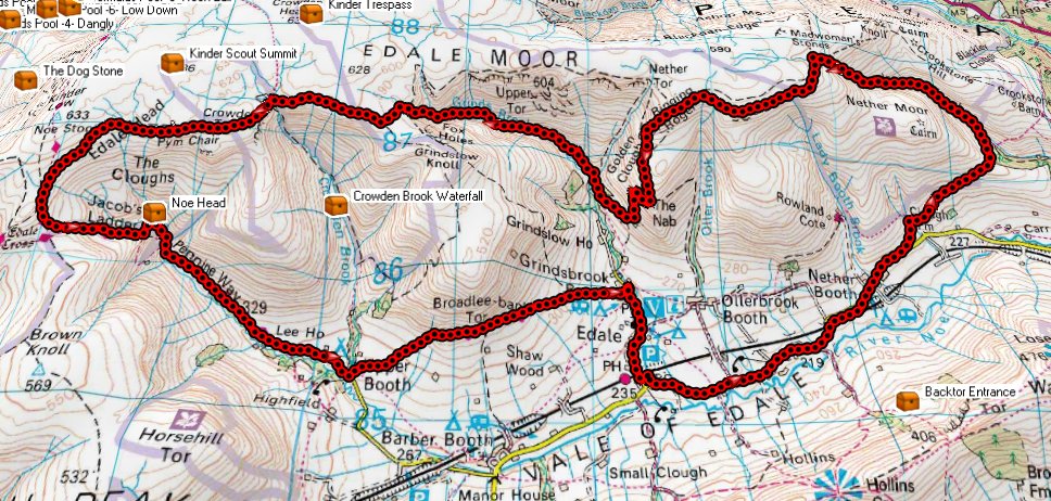
The best hills within a decent driving distance are at one of my favourite walking haunts - Edale and Kinder so I bounced a few ideas back and forth with her before we settled on a plan - we'd do Kinder Scout. Twice.
From past experiences I've found Jagger's Clough and Grindsbrook to be pretty tough ascents so I knocked up a route that started at Edale, headed East and then up Jagger's Clough, West along the top, descend by Ringing Roger, ascend back up Grindsbrook, further West, South and then East down Jacob's Ladder and back to Edale.
From looking at the pre-plotted route you can see why I've called this 'Kinder Butterfly'...
 |
| Kinder Butterfly! |
We met at 9am (prompt this time!) but disappointingly there were only 3 of the Three Peakers (Jane, David and Helen) as well as my sister (Tam), her husband (Rob), my two kids (Adam and Jade) and my friend (Paul.)
It was a scorching day and I'd well prepared before we set off. The kids and I were already suncreamed up, had loads of food and water and also new boots and hats where necessary.
 |
| Approching the start of Jagger's Clough |
 |
| Ascending Jagger's Clough |
 |
| Looking down Jagger's Clough |
 |
| Along the tops |
We had a great ascent up Jagger's Clough and a quick snack break at the top. The climb wasn't half as tough as I'd remembered but that's probably because I'm 3 years fitter.
 |
| Looking over "Ringing Roger" and down to Edale |
 |
| From the same location, looking right toward Grindsbrook - our next climb |
Someone deserted us at the top, not wanting to descend and re-ascend, which caused us no end of delays two hours later trying to meet up.
After descending we stopped under some trees by a stream to have lunch and a rest before continuing with the long climb up Grindsbrook.
 |
| Dexter enjoying our break |
 |
| Lunchtime! Adam, Paul, Jade, David, Helen, Jane, Tam and Dexter. |
 |
| Ascending the lower part of Grindsbrook |
I've never done this part upwards, only downwards last year, but it was fabulous. I was still full of energy (we'd only done 7 miles by the top of this part) and really enjoyed bouncing across rocks and the stream. This is where great boots really come into their own. I had to track back a few times as Jade was beginning to struggle in the heat and because she's not actually very fit so I helped pull her up a fair few steep bits to make it much easier. Lots of fun and something I certainly intend to repeat.
At the top we continued in the same direction actually heading directly away from the cars for a couple of miles before turning and descending at Jacob's Ladder where I'd been with the kids only two months earlier. (But this time feeling MUCH fitter.)
Now a long walk back to the car although we did divert from my original route (spoiling my butterfly!) onto the Trans-Pennine-Trail so that we'd end up at the pub and the ice cream shop rather than just back at the car park.
 |
| Our actual route. (Plotted in 3D here so spoiling the 'butterfly' even more.) |
In my mind I'd arranged a fabulous route but upon execution I do feel that the last third spoils it a little; once you've done the 'up-down-up' then there are two long walks, split by the last 'down', which have little to offer. Normally these would be lovely walks so perhaps it's just the relative disappointment after the previous exertions?
I have to confess to flagging a little for the last two miles - I'd run out of water after finishing my entire two litres of water but I'd not eaten my Mars Bar. Note to self: it's not much use in the rucksack, it's much more effective in my stomach. However I'm blaming it on the heatwave which, although sapping, wasn't actually as unbearable as I'd feared the day before.
A great walk which I must repeat.
Tuesday, 22 May 2012
Stocksbridge to Castleton
Being something of a 'smalltown boy', having been brought up on a farm near Stocksbridge, South Yorkshire, even a place like Sheffield seemed to be a continent away despite the fact it was only about 15 miles. Along similar lines a place such as Castleton was seen as a holiday location even though it was only 20 miles away over all the B-roads or maybe 1 hour 30 minutes driving with my Dad's super-steady pace.
So whilst poring over some digital maps of Kinder Scout recently, in preparation for the National Three Peaks attempt I have in June, it struck me that walking from Stocksbridge to Castleton was something that not only wasn't impossible (as I'd certainly have thought if you'd asked me beforehand) but was actually quite achievable.
So I presented this 'mad plan' to my sister, who is organising the Three Peaks event, and she thought it a good idea. The wheels set in motion - routes planned, dates arranged, people invited and return drivers nominated so that eventually we had 10 walkers and four dogs meeting near Underbank Reservoir (outside our Dad's house) on Saturday 19/05/12 at 9am. Almost all to plan; one car was 20 minutes late.
The weather was miserable with on and off light drizzle all day but it certainly didn't dampen my spirits; I'd have continued with the walk even if it had been heavy rain.
We set off up Clay Pits Lane and then across a couple of fields to the top of Long Lane before walking alongside the woods. Merrily chatting away to people I'd not met before I completely missed our turn-off so we added an unplanned extra loop on before getting back on track at Mortimer Road. Here was another problem - the path I'd planned on using was marked "Private Road" and coupled with the Public Footpath sign missing at the other side of the road I was reluctant to walk down the track past the house and farm even though I know it to be Peak District National Park and that it leads to a published footpath.
Paper maps out (thanks Tam), as it's easier to get the 'big picture', I decided to follow the road down over Ewden Beck and up the other side before turning right onto the moors - 180 degrees the opposite direction to that which I had planned but in actual fact almost exactly the same distance.
Turning right off Mortimer Road, just after the entrance to Broomhead Hall, we followed a well defined track over the moors for a long distance, possibly 2 miles, passing a cache I frustratingly had to leave. Even stopping for 2 minutes means people are a long way in front so I decided at this point to scrap the Geocaching idea for the day, maybe even forever. (I had prepared a list of a possible 11 to do.)
Heading over Broomhead Moor the track ends abruptly, as I knew, and we hoofed it over the heather for about 100m onto the next trail and started heading West and South-West. Arriving at a mini-peak (Round Hill I think) my GPS indicated we should go due South along an obvious path but someone pointed out there was another, unmapped, path heading off about 90 degrees right. Deciding this second path was too far in the wrong direction, and after all the obvious path was going in the right direction, I took the South path but then within two minutes regretted the decision; this, now unmapped path, bore off East - it appears the Ordnance Survey are out of date here.
Not wishing to backtrack I led everyone directly across the heather and boggy moorland for a good half mile before we turned right 90 degrees and joined back onto the planned path near Low Tor. I knew I wasn't lost - after all my GPS knows exactly where we want to be and I can just "follow the arrow" - but I do admit it was a round about route forced upon us through perhaps a little naivety on my part. It's all fun. Well it was to me, I'm not sure many others would have agreed.
Once back on track it was about 3/4 of a mile to Back Tor where we decided to shelter out of the wind and drizzle and have a bite to eat. A fortunate location as it meant I could actually sneak in a quick cache which is hidden there - and a good find it was too; an ammo can packed full of goodies.
We only stopped for 20 minutes because it was cold and I really wanted to push on before anyone started to seize up - even though we'd only done 9 miles so far and indeed everyone was younger than me, almost, there were quite a few non-walkers in the group who I thought might struggle later.
We continued South to the Cakes of Bread (a rock formation), Dovestone Tor along a very wet peat trail, including a few slips and sinkings (yes I went in up to my left knee) before the path became properly paved - something of a luxury for a mile or two.
We passed the Salt Cellar (rocks again), White Tor, along the edge of the Derwent Moors, the Wheel Stones (more rocks), the Hurtling Stones (yep) and on to Whinstone Lee Tor where we took a steep descent towards the top section of Ladybower through Ashopten Woods and to the A57. A walk now East to cross Ladybower on the A6013 and then South to the dam wall heading towards Win Hill near the Yorkshire Bridge public house.
Here there are a couple options and I thought the better option was to take the gently sloping path up Win Hill where it would then lead onto Hope. I was mistaken and this path only leads UP Win Hill so we ended up going up the terribly steep section - it's all good practice we thought.
Half way up Win Hill two of the dogs went missing. One turned up relatively quickly but unfortunately we had to spend 30 minutes wandering around the woods shouting out before ultimately we heard from Bill, who'd waited at all the rucksacks, that the second dog had brought himself back to the start. Bloody mutt!
Cutting across Win Hill at this point we followed what was a much better path than the planned one would have been as the weather had cleared up and we could actually see over the valley towards Bamford.
The end almost in sight we cut across half a dozen fields and farms, directly into Hope, before dropping behind the church and following a well maintained path alongside Peakshole Water for a mile and a half and landing ourselves in the middle of Castleton.
Hurrah! A pint (OK it was two) of Guinness to celebrate our 20.2 mile walk and to congratulate all the group.
A great days walking and my sister and I even considered walking back - part jokingly but then we actually seriously thought about it for another day when we've more provisions and extra pairs of dry socks!
I've never felt fitter and remarkably my muscles were hardly tired; my only niggle is my right ankle (tendons I'm told) which is still nagging me as has been over-documented in several blogs recently. Yes I know there were no real hills but it was still something of an endurance, with the distance, the heather and the mud, and I have to say that I'm chuffed with myself.
Roll on the Three National Peaks!
Tuesday, 15 May 2012
Walla Crag
On Saturday 12/05/12 I joined a group of Geocachers for a "multiple milestones" day up in the Lakes.
I left the house at 6:15 to meet MikeG and Ska Face (Jon) up at M1 J38 and we then wellied it up the M1, A1 and A66 to Keswick.
Arriving in plenty of time for 9:00 (early it transpired) we hung around waiting for the others who were coming for the arranged 9:30.
Eventually we had Mr Truffles (Ernie, who had organised the outing), The Black Pigs (Dave, Sue and Brook the dog), JCB1705 (Charlie), StevieP, Patdhill (Patrick) and of course MikeG, Ska Face and myself.
I was well prepared having had my porridge, and being well packed with sandwiches, tea and emergency Mars bar, as well as multiple layers of clothes ready for whatever the weather could throw at us.
We set off up Walla Crag, after bagging an easy cache at the side of the layby we'd all used, and made good time ascending, picking up 4 caches in a series on the way up.
The cache Ernie had chosen as the multiple milestoner was BT4 just below the peak. The reason for this was the cache "Walla Crag" at the top had already been found previously by Ska Face so he wouldn't be able to claim it.
BT4 became Mr Truffles' 14,000th cache, StevieP's 12,000th cache and Ska Face's 8,000th cache! What an epic set of milestones!
We took a few photos and then quickly reached the top where MikeG hoisted the Yorkshire flag and we celebrated with photos, truffles and sparkling wine!

Ascent of Walla Crag

The Milestoners

Celebrations at the top

View from the peak looking over Derwent Water
with Basenthwaite Lake in the far distance
with Basenthwaite Lake in the far distance
After the next cache we decided to alter our plans and head for Bleaberry Fell (to the strains of some terrible singing) and then onto High Seat as they were both "Wainwrights" a few members hadn't bagged.
We ascended from 340 to 450 metres quite gently but then the route from 450 to 590 was pretty steep and was really good exercise.
The sun was beating down and it was very warm when out of the wind so we stopped for a leisurely lunch here and a good old chinwag before a gentle 40m descent and re-ascent up to High Seat peaking at almost 610m
From here it was a long and steady descent for a while before hitting quite a steep descent down a long trail to Ashness Bridge which is supposedly famous for it's beauty and I'm told adorns many calendars and placemats. I wanted to take a photo but it was crowded with people so I left it alone.
Just above this spot was a fantastic little stream with a perfect picnic spot - I must return one day with the kids and a pretty woman! Unfortunately I didn't get a picture but Ernie took this one nearby...

From here we reclimbed the hill a little heading across to rejoin the original BT cache series we'd previously started, albeit now temporarily in reverse. We then descended via an alternative route all the way down to the original road stopping at another allegedly famous photo spot...

We then simply headed back along the road to the cars, changed out of our muddy boots and all met up in a pub on the A66 to celebrate a tiny bit more with a well-deserved pint (Thanks Jon, I owe you!)
Overall it really was a fantastic day, they don't get much better; 9 miles of excellent views, great weather and fabulous company. I felt fitter than I think I ever have with my muscles and stamina bristling with confidence and energy (the only hiccup was my right ankle which still isn't right.)
Somehow we also managed to get 19 caches which I thought really strange; I had guessed we'd only got about 10.
Thanks all for inviting me and here's looking forward to the 15,000th milestone trip!!
Monday, 14 May 2012
Aches, pains and trainers
I'm not sure whether it was the excessive amount of work and pressure I put on my body at the recent bootcamp or whether it was because I had left my running trainers there and did some runs at home in my 'cheap' trainers, but the upshot of it all was that I ruined my knees, ankles and also got shin-splints.
Either way I could hardly walk for a few days the other week and when I did the 22-mile charity walk last week I struggled more with my joints than I've ever struggled before in my life.
Yes my legs ached, my muscles were tight and ready to ping; all the usual stuff when you work hard for a long period, but these were sharp pains and they weren't very nice.
I took a couple of weeks rest from running because of the pain and also because there was still no sign of my running shoes arriving back from the hotel (lost in the post? never posted?) but I did continue to walk and Saturday just gone I did a fantastic days walk in the Lake District (full blog to follow) and took two things away from it:
1) My muscles and stamina are MUCH better than they ever have been.
2) My right ankle is still painful.
So yesterday I went to Meadowhall and treated myself to a new pair of trainers with the fully moulded insert and additional arch support. This involves laser scanning my feet, hot insoles, leather footrests and slow-motion videoing of me running - all clever stuff and a tad pricey but at the end of the day how much for your health? I'm hoping to walk on these joints for another 40 years and after seeing how I actually run I could tell I really needed support.
Fantastic service and hopefully well worth the money. I've been told to wear the insoles in all my footwear including my day-to-day shoes (they are easily removable) but I think the real tests will be running (when my ankle is less painful) and long distance hiking - just like I've got planned on Saturday - more news in a couple of blogs when it's been and gone!
Subscribe to:
Comments (Atom)